Near Hopwood in Fayette County, Pennsylvania — The American Northeast (Mid-Atlantic)
History Flows Through These Waters
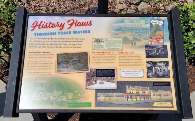
For thousands of years, people have used this year-round water source. They filled skins, canteens, whiskey jugs, and radiators; they watered horses and shared stories. From long-ago hunters tracking game to travelers on US Route 40, history flows through the spring's water.
Where Water Flows, People Follow
After the Revolutionary War, William Downard lived in a house built against the hillside. People and goods flowed past on the new National Road. There was a tavern every mile, and times were good.
Downard's clearing was too small for a wagon yard and tavern, but there was enough space to pull over for a water break. He diverted the spring water to a large wooden trough, creating a travelers' oasis. Downard's water was free, but legend says that if he didn't like you, he wouldn't let you have any.
In the 1850s, travel shifted to trains. The National Road deteriorated, and the house fell into disrepair.
Coal is King, and Money Flows In
In the early 1900s, workers processed coal for the Industrial Revolution. City folks day-tripped from Pittsburgh for fresh air. Newly wealthy-including Thomas Edison, Henry Ford, and the Vanderbilt and Heinz families - vacationed at the Summit inn, stopping here to top-up radiators and cool overheated brakes.
Good Times Ebb and Flow
The Big Watering Trough Restaurant, followed by the Empire Dance Hall, replaced the Mountain Water Club. When the coal industry ebbed in the 1950s, the dance hall closed. Local businessman Don Shoemaker purchased the ailing restaurant, which was destroyed by fire in 1997. In 2020, the Shoemaker family donated the land to be used as a park honoring the watering trough and its history.
Where Stories Flourish, History Flows
What stories will you share?
Where will history take you?
[Photo Captions]:
In 1907, Uniontown multi-millionaire J.V. Thompson built the men's Mountain Water Club, for "whisky and cards." It burned down in 1914.
Cars, money, and a steep hill; the perfect combination for the new sport of car racing! From 1913-1915, this site became the Summit Hill Climb staging area. Thousands of spectators cheered famous drivers, including Barney Oldfield and Louis Chevrolet.
The Mountain Water Club included a large oven east of the house used for ox, pig, and lamb roasts.
Summit Inn lounge, ca 1950s
Summit Inn lobby, with original furniture
Empire Dance Club advertised, "If you don't dance, we will teach you!"
Erected 2020 by Fayette County Historical Society.
Topics. This historical marker is listed in these topic lists: Entertainment • Industry & Commerce.
Location. 39° 51.588′ N, 79° 39.722′ W. Marker is near Hopwood, Pennsylvania, in Fayette County. Marker is on National Pike (U.S. 40) 0.8 miles west of Jumonville Road (Pennsylvania Route 2021), on the right when traveling west. Marker is located at the Watering Trough roadside pulloff only accessible from the westbound lanes. Touch for map. Marker is in this post office area: Hopwood PA 15445, United States of America. Touch for directions.
Other nearby markers. At least 8 other markers are within 2 miles of this marker, measured as the crow flies. History Flows Through This Land (a few steps from this marker); Braddock Road (approx. ¾ mile away); Washington–Braddock Road 1754–1756 (approx. 0.9 miles away); Washington’s Spring (approx. 0.9 miles away); Historic Stone Chimneys (approx. 1.2 miles away); The Perfect Brick Machine (approx. 1.2 miles away); From Jumonville to a World War (approx. 1.7 miles away); Jumonville Glen (approx. 1.7 miles away). Touch for a list and map of all markers in Hopwood.
Credits. This page was last revised on May 27, 2022. It was originally submitted on May 24, 2022, by Bradley Owen of Morgantown, West Virginia. This page has been viewed 788 times since then and 135 times this year. Last updated on May 26, 2022, by Bradley Owen of Morgantown, West Virginia. Photos: 1, 2, 3, 4. submitted on May 24, 2022, by Bradley Owen of Morgantown, West Virginia. • J. Makali Bruton was the editor who published this page.


