Sterling in Loudoun County, Virginia — The American South (Mid-Atlantic)
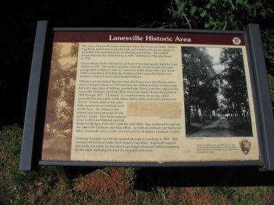
Lanesville Historic Area
Claude Moore Park is located on portions of two land grands made by Lord Fairfax in 1729. The western section, where the Visitor Center is located, was granted to Robert Carter, Jr. Land east of the stream that runs under Vestal's Gap Road, including the location of the Lanesville House, was granted to sisters Frances and Elizabeth Barnes.
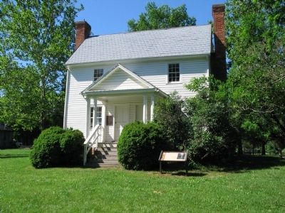
William Lane purchased the land from the King sisters (the Barnes sisters married King brothers) in 1779 and built the earliest portions of this house. Keturah Lane, niece of William, married John Keene, and they operated the Lanesville Ordinary and Post Office from their home during the period of 1808 through 1817. "Ordinary" is a southern term for an inn, which generally had one public room where family-style meals and drinks were served. Patrons slept in the extra beds upstairs or on cornhusk mats on the floor. The ordinary also offered feed and pasturage for the patrons' horses. John Keene passed away in 1814 and Keturah married Benjamin Bridges; from 1817 until the mid-1820s, they continued to operate the Lanesville Ordinary and Post Office. As both an ordinary and local post office, Lanesville was a center of social activity in eastern Loudoun County.
Leesburg Turnpike was finally opened through to Leesburg in 1825. This removed all but local traffic from Vestal's Gap Road. Improved wagons also made it possible for travelers to go longer distances without stopping for the night, reducing the need for frequent ordinaries.
Vestal's Gap Road and the Lanesville Historic Area are listed on the National Register of Historic Places maintained by the National Park Service, United States Department of the Interior.
Topics and series. This historical marker is listed in this topic list: Roads & Vehicles. In addition, it is included in the Postal Mail and Philately series list. A significant historical year for this entry is 1692.
Location. 39° 1.069′ N, 77° 24.235′ W. Marker is in Sterling, Virginia, in Loudoun County. Marker is on Old Vestals Gap Road, on the right when traveling west. Located in front of the Lanesville House, along a foot path over the Old Vestal's Gap Road trace in Claude Moore Park. Touch for map. Marker is in this post office area: Sterling VA 20164, United States of America. Touch for directions.
Other nearby markers. At least 8 other markers are within walking distance of this marker. Lanesville House and Vestal's Gap Road (here, next to this marker); Lanesville Architecture (a few steps from this marker); Vestal's Gap Road (a few steps from this marker); Lanesville Outbuildings (a few steps from this marker); Lanesville Families (a few steps from this marker); The Braddock Campaign (within shouting distance of this marker); Vestal's Gap Road in the 1800s (about 300 feet away, measured in a direct line); Guilford Signal Station (about 500 feet away). Touch for a list and map of all markers in Sterling.
More about this marker. The marker displays a facsimile of the Lanesville Ordinary License. On the right is a photo of the Old Vestal's Gap Road.
Also see . . . Vestal's Gap Road and Lanesville Historic District. (PDF) National Register documentation for the site. (Submitted on June 20, 2009, by Craig Swain of Leesburg, Virginia.)
Credits. This page was last revised on August 15, 2022. It was originally submitted on June 20, 2009, by Craig Swain of Leesburg, Virginia. This page has been viewed 2,330 times since then and 76 times this year. Last updated on August 15, 2022, by Carl Gordon Moore Jr. of North East, Maryland. Photos: 1, 2, 3. submitted on June 20, 2009, by Craig Swain of Leesburg, Virginia. • Bernard Fisher was the editor who published this page.


