Petersburg, Virginia — The American South (Mid-Atlantic)
The Battle at the Bridge
The Revolutionary War
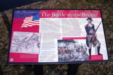
In the late afternoon and evening of 24 April 1781, Virginia militia regiments of Brigadier General Peter Muhlenberg’s Corps of about 1,000 men marched into Petersburg in order to counter an expected attack by the invading 2,500 man British army of Major General William Phillips the following day. That evening, Major General Frederick von Steuben, the overall American commander in Virginia, ordered Muhlenberg’s Corps and other gathering militia to the north side of the Appomattox River in the community of Pocahontas and onto the heights overlooking the river (now Colonial Heights) for the night. On the morning of the 25th, von Steuben and MuhIenberg began deploying their force to defensive positions on the eastern edges of Blandford and Petersburg. Concurrently, von Steuben left Colonel Robert Goode’s militia regiment of Chesterfield County and Captain Robert Bolling’s company of Cavalry in Pocahontas to secure the militia’s rear and provide covering fire for operations on the south of the river.
The initial British attack began near 1:00 o’clock. Around 3:00 o’clock in the afternoon, following intense fighting against overwhelming odds, von Steuben ordered a general withdrawal of the militia from Petersburg into Chesterfield County. The Americans had held their principal defensive position along what is now Madison Street against several assaults by Phillips’ overwhelming British regulars. However, with ammunition running low and British artillery battering the militia lines, von Steuben determined that his force had accomplished as much as they could to defend the town. With British forces in close pursuit, the militia fought a bitter hand-to-hand delaying action along this waterfront while individual units crossed the narrow Pocahontas Bridge to safety. The last units across took up the bridge planks to delay the enemy’s following. Though it had withdrawn from Petersburg, the brave Virginia militia had impeded the British invasion and remained intact to fight another day.
Topics. This historical marker is listed in these topic lists: Bridges & Viaducts • War, US Revolutionary. A significant historical date for this entry is April 25, 1781.
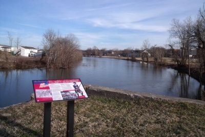
Location. 37° 14.126′ N, 77° 24.168′ W. Marker is in Petersburg, Virginia. Marker is on Pocahontas Street, 0.1 miles west of 3rd Steet, on the right when traveling west. Touch for map. Marker is in this post office area: Petersburg VA 23803, United States of America. Touch for directions.
Other nearby markers. At least 8 other markers are within walking distance of this marker. Pocahontas (about 400 feet away, measured in a direct line); Pocahontas Island (about 500 feet away); Charles Stewart (about 500 feet away); South Side Station (about 700 feet away); a different marker also named South Side Station (about 700 feet away); The McIlwaine House (approx. 0.2 miles away); Bollingbrook Hotel (approx. 0.2 miles away); Farmers Market (approx. 0.2 miles away). Touch for a list and map of all markers in Petersburg.
More about this marker. On the lower left is a map carrying the caption, “The map above was drawn by John Hills, a lieutenant and assistant engineer in the 23rd Regiment, British Army. The map was published in London by William Faden, Geographer to King George III, at Charing Cross, on May 3, 1784.”
On the right is an image of “Brigadier General Peter Muhlenberg from an engraving by Frederick Girsch, courtesy of the Library of Congress.”
On the lower right is an image of “The Battle of Petersburg.” Courtesy of the Artist, Pamela Patrick White.
Also see . . . American Revolution Round Table - Richmond. The ARRT-R is devoted to the study of all aspects of the Revolutionary period (ca. 1763-89). (Submitted on January 24, 2010.)
Credits. This page was last revised on February 2, 2023. It was originally submitted on January 24, 2010, by Bernard Fisher of Richmond, Virginia. This page has been viewed 1,204 times since then and 16 times this year. Photos: 1, 2. submitted on January 24, 2010, by Bernard Fisher of Richmond, Virginia.

