Near Harmony in Butler County, Pennsylvania — The American Northeast (Mid-Atlantic)
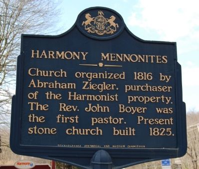
Harmony Mennonites
Erected 1947 by Pennsylvania Historical and Museum Commission.
Topics and series. This historical marker is listed in this topic list: Churches & Religion. In addition, it is included in the Communal and Utopian Societies, and the Pennsylvania Historical and Museum Commission series lists. A significant historical year for this entry is 1816.
Location. 40° 48.567′ N, 80° 7.656′ W. Marker is near Harmony, Pennsylvania, in Butler County. Marker is on Wise Road, on the right when traveling east. Touch for map. Marker is in this post office area: Harmony PA 16037, United States of America. Touch for directions.
Other nearby markers. At least 8 other markers are within walking distance of this marker. George Washington Slept Here (approx. 0.3 miles away); Harmonist - Ziegler Barn (approx. 0.3 miles away); Ca. 1805 Log Cabin (approx. 0.4 miles away); Rapp's Seat Vineyard Hill (approx. half a mile away); Veterans Memorial (approx. half a mile away); Harmony (approx. half a mile away); Visitor Information Center (approx. half a mile away); Harmonist Cemetery (approx. 0.6 miles away). Touch for a list and map of all markers in Harmony.
Credits. This page was last revised on November 27, 2020. It was originally submitted on February 18, 2011. This page has been viewed 921 times since then and 25 times this year. Last updated on November 26, 2020, by Sam Skeen of Cranberry Township, Pennsylvania. Photos: 1, 2. submitted on February 18, 2011, by Mike Wintermantel of Pittsburgh, Pennsylvania. • J. Makali Bruton was the editor who published this page.

