Near Brandy Station in Culpeper County, Virginia — The American South (Mid-Atlantic)
The 1863-64 Winter Encampment
The Federal Army of the Potomac Rebuilds
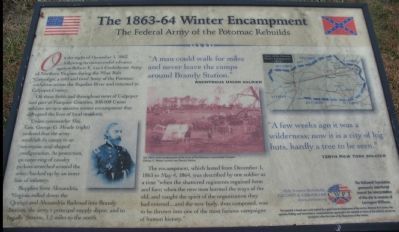
On the night of December 1, 1863, following its unsuccessful advance against Robert E. Lee's Confederate Army of Northern Virginia during the Mine Run Campaign, a cold and tired Army of the Potomac withdrew across the Rapidan River and returned to Culpeper County.
On these fields and throughout most of Culpeper and part of Fauquier Counties, 100,000 Union soldiers set up a massive winter encampment that disrupted the lives of local residents
Union commander Maj. Gen. George G. Meade (right) ordered that the army establish its camps in an enormous oval-shaped configuration. As protection, an outer ring of cavalry pickets stretched around the army, backed up by an inner line of infantry.
Supplies from Alexandria, Virginia rolled down the Orange and Alexandria Railroad into Brandy Station, the army's principle supply depot, and to Ingalls Station, 1.2 miles to the north.
The encampment, which lasted from December 1, 1863 to May 4, 1864, was described by one soldier as a time "when the shattered regiments regained form and fair; when the new men learned the ways of the old, and caught the spirit of the organization they had entered... and the new body, thus composed, was to be thrown into one of the most furious campaigns of human history."
"A man could walk for miles and never leave the camps around Brandy Station."
Anonymous Union Solder
"A few weeks ago it was a wilderness; now it is a city of log huts, hardly a tree to be seen."
126th New York Soldier
Help Preserve Battlefields • call CWPT at 1-888-606-1400 • www.civilwar.org • The Hallowell Foundation generously contributed toward the interpretation of this site in memory of Carrington Williams.
This material is based upon work assisted by a grant from the Department of the Interior, National Park Service. Any opinion, findings and conclusions or recommendations expressed in this material are those of the author(s) and do not necessarily reflect the views of the Department of the Interior.
Erected by Civil War Preservation Trust.
Topics. This historical marker is listed in this topic list: War, US Civil. A significant historical date for this entry is May 4, 1864.
Location. 38° 31.379′ N, 77° 51.923′ W. Marker is near Brandy Station, Virginia, in Culpeper County. Marker is at the intersection of Beverly Ford Road (County Route 677) and St. James Church Road (County Route 676), on the left when traveling north on Beverly Ford Road. Located at the first trail stop for the St. James Church Walking Trail of the the Battle of Brandy Station. Touch for map. Marker is in this post office area: Brandy Station VA 22714, United States of America. Touch for directions.
Other nearby markers. At least 8 other markers are

Photographed By Craig Swain, December 22, 2007
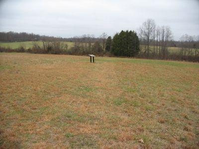
2. Stop One on the St. James Church Walking Trail
Battle of Brandy Station Virtual Tour by Markers.
A set HMDb markers that document the Battle of Brandy Station, June 9, 1863, and the Winter Encampment of 1863-64. Note the order of appearance is geographic and not chronologically aligned to the battle.
Click for more information.
A set HMDb markers that document the Battle of Brandy Station, June 9, 1863, and the Winter Encampment of 1863-64. Note the order of appearance is geographic and not chronologically aligned to the battle.
Click for more information.
More about this marker. On the left is a portrait of General Meade. In the center is a photograph of "The 1864 winter headquarters of the Army of the Potomac's commander General George G. Meade located near Brandy Station." On the right a map shows the "Army of the Potomac winter encampments, 1863-64."
Regarding The 1863-64 Winter Encampment. This is one of several markers interpreting the Battle of Brandy Station and the winter encampments of 1863-64 in Culpeper County. See the Battle of Brandy Station Virtual Tour by Markers linkfor additional related markers.
Also see . . .

Photographed By Craig Swain
3. The Battle of Brandy Station
St. James Church Walking Trail
St. James Church Walking Trail
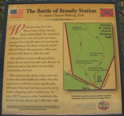
Welcome to the Civil War Preservation Trust's Brandy Station Battlefield! The battlefield walking trail is a one-mile path that takes you past four wayside signs interpreting the 1863 fighting at St. James Church and the 1863-64 Winter Encampments. Allow one and one-half hour to walk this trail.
The trail has a mown walking surface; please do not stray from this trail. Beware of ticks and snakes that thrive in the fields surrounding the trail.
Most importantly, please enjoy your time in these beautiful fields and reflect that this experience would have been significantly different if this land had been paved over to build a shopping mall or subdivision. To help CWPT preserve other battlefields like Brandy Station, please call 1-888-606-1400.
This material is based upon work assisted by a grant from the Department of the Interior, National Park Service. Any opinion, findings and conclusions or recommendations expressed in this material are those of the author(s) and do not necessarily reflect the views of the Department of the Interior.
The Hallowell Foundation generously contributed toward the interpretation of this site in memory of Carrington Williams.
To the left of the text is a map showing the trail stops.
Credits. This page was last revised on November 14, 2022. It was originally submitted on December 24, 2007, by Craig Swain of Leesburg, Virginia. This page has been viewed 2,099 times since then and 44 times this year. Photos: 1, 2, 3. submitted on December 24, 2007, by Craig Swain of Leesburg, Virginia.
