Jamestown in Newport County, Rhode Island — The American Northeast (New England)
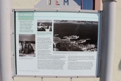
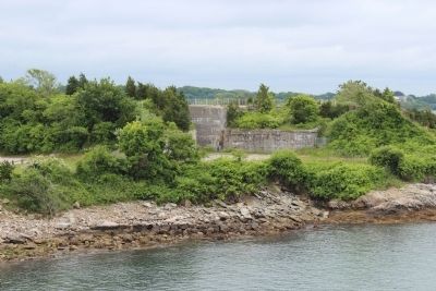
Fort Wetherill
The government acquired the first parcels of land for this fort in 1799. Additional acreage was later purchased bringing the total area of this military reservation to 61.5 acres. In 1900, the enclave was formerly dedicated and named Fort Wetherill.
This site contains the largest concrete fortifications of its kind in Rhode Island. Because of spatial constraints it was laid out in an uncommonly tight linear array, featuring a variety of gun sizes and types, from 12-inch barbette mounted and disappearing rifles, to the smaller 6-inch and 3-inch pedestal types.
The majority of the mounted guns, and the barracks that housed officers and enlisted personnel, were located at the western end of the reservation, now known as Fort Wetherill State Park. Most of the military personnel serving at the fort during World War II were members of Rhode Island's own 243rd Coast Artillery Regiment, some of whom later chose to become permanent residents of the town of Jamestown. During the later part of 1945, selected German prisoners of war trained in this area for a postwar German police force. After the war a number of the wooden barracks were acquired by local citizens and relocated to sites throughout town.
A complete Submarine Mine and Cable facility consisting of several buildings, a wharf, tram rails, and ancillary facilities occupied the easternmost section of the fort during the World Wars. Three permanent structures have been preserved and upgraded, and now house the offices of the Department of Environmental Management Division of Fish and Wildlife.
Topics. This historical marker is listed in these topic lists: Forts and Castles • War, World I • War, World II • Waterways & Vessels. A significant historical year for this entry is 1799.
Location. 41° 28.726′ N, 71° 21.473′ W. Marker is in Jamestown, Rhode Island, in Newport County. Marker is on Fort Wetherill Road, on the left when traveling south. Follow Fort Wetherill Road to the end marker is in front of first building on left. Touch for map. Marker is in this post office area: Jamestown RI 02835, United States of America. Touch for directions.
Other nearby markers. At least 8 other markers are within one mile of this marker, measured as the crow flies. Harbor Mine (Torpedo) Complex (a few steps from this marker); History of the Dumplings (within shouting distance of this marker); U.S.S. Bennington CVA-20 (approx. 0.8 miles away); John Adams (approx. 0.8 miles away); Southwest Battery (approx. one mile away); Between the Wars (approx. one mile away); Changing Role of the Fort (approx. one mile away); Three Tiers of Firepower (approx. one mile away). Touch for a list and map of all markers in Jamestown.
Also see . . . Fort Wetherill (Wikipedia). (Submitted on June 22, 2012, by Bryan Simmons of Attleboro, Massachusetts.)
Credits. This page was last revised on January 12, 2022. It was originally submitted on June 22, 2012, by Bryan Simmons of Attleboro, Massachusetts. This page has been viewed 880 times since then and 13 times this year. Last updated on January 6, 2022, by Carl Gordon Moore Jr. of North East, Maryland. Photos: 1, 2. submitted on June 22, 2012, by Bryan Simmons of Attleboro, Massachusetts. • Michael Herrick was the editor who published this page.

