Manor Township near Washington Boro in Lancaster County, Pennsylvania — The American Northeast (Mid-Atlantic)
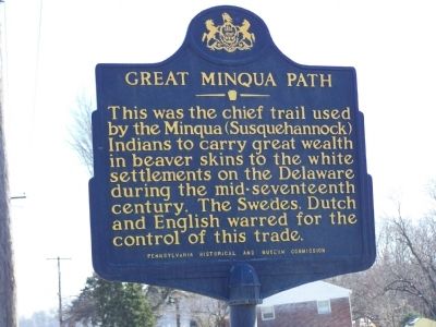
Great Minqua Path
Erected 1951 by Pennsylvania Historical and Museum Commission.
Topics and series. This historical marker is listed in these topic lists: Colonial Era • Industry & Commerce • Native Americans. In addition, it is included in the Pennsylvania Historical and Museum Commission series list.
Location. 39° 58.664′ N, 76° 27.581′ W. Marker is near Washington Boro, Pennsylvania, in Lancaster County. It is in Manor Township. Marker is on River Road (Pennsylvania Route 3030) 0.3 miles south of Blue Rock Road, on the right when traveling south. Touch for map. Marker is at or near this postal address: 2319 River Rd, Washington Boro PA 17582, United States of America. Touch for directions.
Other nearby markers. At least 8 other markers are within 2 miles of this marker, measured as the crow flies. The Atglen & Susquehanna Low Grade (approx. 0.9 miles away); Moving Heaven and Earth (approx. 0.9 miles away); Washington Boro Archaeological Sites (approx. one mile away); Turkey Hill Dairy proudly salutes (approx. 1.4 miles away); Martin Chartier (approx. 1.6 miles away); 40th Parallel (approx. 1.7 miles away); Susquehanna and Tidewater Canal (approx. 1.8 miles away); Susquehanna Canal (approx. 1.8 miles away). Touch for a list and map of all markers in Washington Boro.
Credits. This page was last revised on February 7, 2023. It was originally submitted on February 25, 2008, by Bill Pfingsten of Bel Air, Maryland. This page has been viewed 2,052 times since then and 22 times this year. Last updated on November 17, 2020, by Carl Gordon Moore Jr. of North East, Maryland. Photos: 1, 2. submitted on February 25, 2008, by Bill Pfingsten of Bel Air, Maryland.

