Belle and Mayo Islands in Richmond, Virginia — The American South (Mid-Atlantic)
Civil War POW Camp
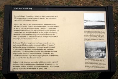
After the war began in 1861, military prisoners jammed Richmond’s jails and warehouses, until North and South signed a formal agreement on July 22, 1862, for prisoner exchanges. That month, Confederate authorities constructed a camp here on Belle Isle, and by the end of July 5,000 enlisted men were packed into it. At first, despite the crowding, the weather was tolerable and the guards let the men bathe in the river. By September 23, before it turned cold, most prisoners had been exchanged, and the camp was closed.
In January 1863, however, prisoner exchanges stopped, and once again captured Federal soldiers were confined here. A “tent city” and wooden support buildings were soon constructed, thousands of prisoners filled the camp, supplies dwindled, and conditions deteriorated. Life here became intolerable the next winter, and men allegedly froze for lack of tents and blankets. In February 1864, Confederate authorities began dispersing the prisoners to other camps, and on March 24 the Belle Isle camp closed.
On June 7, 1864, the prison reopened to hold Union soldiers captured during the Federal campaign toward Richmond. Because the city was threatened, however, most were soon transported south. The camp was virtually empty when Richmond fell on April 3, 1865.
Erected by Richmond National Battlefield Park.
Topics. This historical marker is listed in this topic list: War, US Civil. A significant historical month for this entry is January 1863.
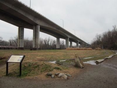
Location. 37° 31.88′ N, 77° 27.044′ W. Marker is in Richmond, Virginia. It is in Belle and Mayo Islands. Marker can be reached from Tredegar Street, 0.3 miles west of South 5th Street. Located on Belle Isle which can be reached via a pedestrian bridge from the north bank of the river. Touch for map. Marker is at or near this postal address: 470 Tredegar Street, Richmond VA 23219, United States of America. Touch for directions.
Other nearby markers. At least 8 other markers are within walking distance of this marker. Belle Isle Prison Camp Monument (here, next to this marker); The Power of Moving Water (within shouting distance of this marker); Historic Belle Isle (within shouting distance of this marker); a different marker also named Historic Belle Isle (within shouting distance of this marker); Old Dominion Iron & Steel Company (about 300 feet away, measured in a direct line); Canons (sic) and Corpses (about 600 feet away); Cannon over the Camp (about 700 feet away); Ironworks Oil House (about 700 feet away). Touch for a list and map of all markers in Richmond.
More about this marker. (captions)
Taken from the north bank of the James River, this photograph shows the prison camp area and some of the prison buildings on the left or eastern end of Belle Isle. Up the hill to the right, the road led to the gun emplacements overlooking the camp, as well as to an artillery battery on the island’s western end. The photograph was probably taken in April 1865. Courtesy Library of Congress and Michael Gorman
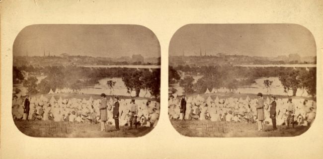
Richmond photographer Charles R. Rees recorded this image in the summer of 1863, before any wooden structures had been built on the end of Belle Isle near the distant tents. To the left of the man in the gray suit and dark hat can be seen the wheel of a cannon limber and a sponge for cleaning the barrel. Courtesy Michael Gorman
Also see . . . Information about Belle Isle Prison in Richmond, VA during the Civil War. Civil War Richmond (Submitted on April 1, 2013.)

Photographed By Charles R. Rees, 1863
3. The Union prison camp at "Belle Isle," Richmond, Va.
Stereograph showing Maj. Thomas P. Turner, Commandant of the "Libby Prison," dressed in gray, with felt hat on, standing on hill overlooking the Confederate prison encampment on Belle Isle in the James River. Confederate guard tents are near the river in the distance. Library of Congress [LOT 4181, no. 204]
Credits. This page was last revised on February 1, 2023. It was originally submitted on March 31, 2013, by Bernard Fisher of Richmond, Virginia. This page has been viewed 1,043 times since then and 61 times this year. Photos: 1, 2. submitted on March 31, 2013, by Bernard Fisher of Richmond, Virginia. 3, 4. submitted on April 1, 2013, by Bernard Fisher of Richmond, Virginia.


