Avila Beach in San Luis Obispo County, California — The American West (Pacific Coastal)
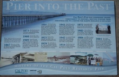
Pier Into The Past
History of the Cal Poly Research Pier

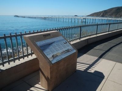
Photographed By Barry Swackhamer, October 5, 2013
1. Pier Into The Past Marker
Captions:
Unocal Vice President Mark Smith
(right) presents Cal Poly President Baker
(left) with a check representing the estimated value of the new Cal Poly pier.
(upper right);
(lower row of photos, left to right) Late 1870s Harford Pier; 1914 Pacific Coast Railway Pier constructions; A thankful telegraph to Union Oil 1942; Collapsing Union Oil Pier during 1883 storm; 1984 Reconstruction of Unocal Pier; Grateful acceptance of new facility in 2001; Rainbow show during dedication ceremony.
For thousands of years the Chumash Native Americans made their home on the Central Coast, including the Avila Beach area.
1867 The town of Avila is established when the Miguel Avila family subdivides Rancho San Miguelito.
1873 John Harford erects the Harford Pier, to facilitate shipping and trading on the Central Coast.
1908 Present day Avila Pier is constructed.
1908 Union Oil and other companies begin building the largest oil pipeline to date. Over 200 miles of oil pipeline is laid from the San Joaquin Valley to Avila. The first oil arrives at Port San Luis in March 1910.
1914 - 1922 The Pacific Coast Railway Co. builds a third pier in San Luis Obispo Bay for commercial shipping. Union Oil Co. of CA (later Unocal) leased the new pier and expands is operations. At this time, Avila becomes one of the largest crude oil shipping ports in the world.
1923 Harford Pier closes to oil shipping. All oil now ships via the Pacific Coast Railway Pier.
1929 The oil facility is abandoned during the Great Depression. 1400 feet of the Harford Pier is demolished to aid navigation in the bay.
1941 Union Oil acquires the Pacific Coast Railway pier and changes its name to the Union Oil Pier. The U.S. Naval fleet fuels the pier during the war years. Union Oil tanker Montebello is sunk by a torpedo near San Simeon, only hours after fueling at the port. Miraculously, no lives are lost.
1942 Lt. General Dwight D. Eisenhower sends Union Oil a telegraph thanking the employees for their efforts during WWII.
1954 The Port San Luis Harbor District is created to revitalize the Harford Pier and surrounding area.
1972 Sustainable goals for Port San Luis are set by the newly founded California Coastal Commission.
1983 A fierce March storm destroys the Union Oil Pier. Three employees are rescued from the collapsing pier by crew of the Paul Revere.
1984 -mid 1990s A modern steel and concrete pier is constructed in the old pier’s original footprints. The new pier extends over 3000 feet into San Luis Obispo Bay. The pier transports an average of 8 to 19 million barrels of oil products per year until Unocal concludes its oil operation at the pier.
2001 On a rainy November day, Unocal donates the pier to Cal Poly’s Center for Coastal Marine Sciences. A beautiful rainbow breaks through the heavy clouds and descends on Avila Beach, an auspicious beginning to Cal Ploy’s new research center.
Cal Poly
Center for Coastal Marine Sciences
Erected by Cal Poly Center for Coastal Marine Sciences.
Topics and series. This historical marker is listed in these topic lists: Science & Medicine • Waterways & Vessels. In addition, it is included in the Former U.S. Presidents: #34 Dwight D. Eisenhower series list. A significant historical month for this entry is March 1910.
Location. 35° 10.681′ N, 120° 44.441′ W. Marker is in Avila Beach, California, in San Luis Obispo County. Marker is on Avila Beach Drive west of Ana Bay Road, on the left when traveling west. Touch for map. Marker is at or near this postal address: 3254 Avila Beach Drive, Avila Beach CA 93424, United States of America. Touch for directions.
Other nearby markers. At least 8 other markers are within 7 miles of this marker, measured as the crow flies. Port San Luis (approx. one mile away); Port Harford Pier (approx. one mile away); Sailing Ship Anchor (approx. one mile away); Port Harford Wharf & Pacific Coast Railway (approx. one mile away); Point San Luis Light Station (approx. 1.7 miles away); The History of Pismo Beach Wharf and Pier (approx. 6.1 miles away); History of Pismo Clams in California (approx. 6.1 miles away); Pismo Beach Pier Plaza (approx. 6.2 miles away). Touch for a list and map of all markers in Avila Beach.
Credits. This page was last revised on July 29, 2020. It was originally submitted on November 7, 2013, by Barry Swackhamer of Brentwood, California. This page has been viewed 630 times since then and 43 times this year. Last updated on November 24, 2013, by Barry Swackhamer of Brentwood, California. Photos: 1, 2, 3. submitted on November 7, 2013, by Barry Swackhamer of Brentwood, California. • Andrew Ruppenstein was the editor who published this page.

