Atoka in Atoka County, Oklahoma — The American South (West South Central)
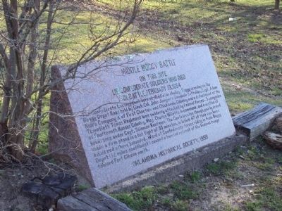
Middle Boggy Battle
On this site lie Confederate Soldiers who died in battle, February 13, 1864
Erected 1959 by Oklahoma Historical Society.
Topics and series. This historical marker is listed in these topic lists: Cemeteries & Burial Sites • Native Americans • War, US Civil. In addition, it is included in the Oklahoma Historical Society series list.
Location. 34° 23.938′ N, 96° 7.001′ W. Marker is in Atoka, Oklahoma, in Atoka County. Marker can be reached from U.S. 69. The marker is located within the Confederate Memorial Park at the entrance to the small cemetery which contains a number of Confederate graves. Touch for map. Marker is at or near this postal address: Confederate Memorial Museum, 258 US 69, Atoka, OK, Atoka OK 74525, United States of America. Touch for directions.
Other nearby markers. At least 8 other markers are within 12 miles of this marker, measured as the crow flies. Historic Butterfield Trail in Indian Territory (a few steps from this marker); Cornerstone from [Atoka] County Courthouse (approx. 1.1 miles away); War Memorial (approx. 1.1 miles away); 45th Infantry Division Memorial Highway (approx. 1.1 miles away); Vietnam War Memorial (approx. 1.1 miles away); Captain Atoka (approx. 1.1 miles away); Stringtown Shootout (approx. 5.4 miles away); Courthouse (approx. 11.2 miles away). Touch for a list and map of all markers in Atoka.
More about this marker. This marker contains mostly excellent information except it is in the wrong place. The actual battle site is approximately 60 miles Northwest, approximately four miles south of the town of Allen, Oklahoma. Early historians believed the cemetery with the Confederate soldiers were the dead from the battle, but later research determined they were casualties of a measles outbreak within the 19th Arkansas Infantry who were stationed at this crossing of the Texas Road. It is not known where the battle dead were buried and there is no marker at the actual battle site.
Credits. This page was last revised on April 11, 2024. It was originally submitted on April 4, 2013, by Michael Manning of Woodlawn, Tennessee. This page has been viewed 1,539 times since then and 128 times this year. Last updated on April 10, 2024, by Vince Curtis of Weston, Florida. Photo 1. submitted on April 4, 2013, by Michael Manning of Woodlawn, Tennessee. • Devry Becker Jones was the editor who published this page.
Editor’s want-list for this marker. A photo of the marker and the surrounding area in context. • Can you help?
