Mechanicsville in Hanover County, Virginia — The American South (Mid-Atlantic)
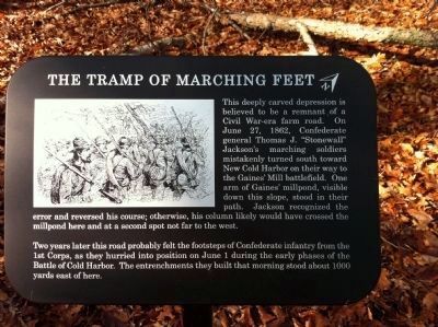
The Tramp of Marching Feet
Two years later this road probably felt the footsteps of Confederate infantry from the 1st Corps, as they hurried into position on June 1 during the early phases of the Battle of Cold Harbor. The entrenchments they built that morning stood about 1000 yards east of here.
Erected 2014 by National Park Service.
Topics. This historical marker is listed in this topic list: War, US Civil. A significant historical month for this entry is June 1837.
Location. 37° 35.528′ N, 77° 17.704′ W. Marker is in Mechanicsville, Virginia, in Hanover County. Marker can be reached from the intersection of Anderson-Wright Drive and Cold Harbor Road (Virginia Route 156) when traveling west. Touch for map. Marker is at or near this postal address: 5515 Anderson-Wright Drive, Mechanicsville VA 23111, United States of America. Touch for directions.
Other nearby markers. At least 8 other markers are within walking distance of this marker. Firing Blind (about 400 feet away, measured in a direct line); Between the Lines (approx. 0.3 miles away); Confederate Breastworks (approx. 0.3 miles away); Confederate Fortifications (approx. 0.4 miles away); Confederate Position (approx. 0.4 miles away); The Cold Harbor Killing Fields (approx. half a mile away); Grant's Grand Assault (approx. half a mile away); The Waters Ran Red (approx. half a mile away). Touch for a list and map of all markers in Mechanicsville.
More about this marker. This trail side marker is part of the new 0.9 mile walking trail on the western end of the Cold Harbor battlefield park.
Also see . . . Richmond National Battlefield Park. National Park Service (Submitted on December 6, 2014.)
Credits. This page was last revised on June 16, 2016. It was originally submitted on December 6, 2014, by Shane Oliver of Richmond, Virginia. This page has been viewed 492 times since then and 13 times this year. Last updated on December 21, 2014, by Shane Oliver of Richmond, Virginia. Photo 1. submitted on December 6, 2014, by Shane Oliver of Richmond, Virginia. • Bernard Fisher was the editor who published this page.
