Near Richmond in Henrico County, Virginia — The American South (Mid-Atlantic)
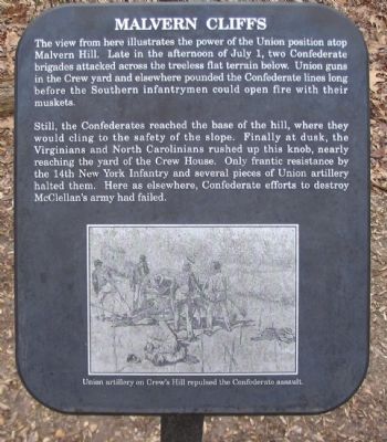
Malvern Cliffs
Still, the Confederates reached the base of the hill, where they would cling to the safety of the slope. Finally at dusk, the Virginians and North Carolinians rushed up this knob, nearly reaching the yard of the Crew House. Only frantic resistance by the 14th New York infantry and several pieces of Union artillery halted them. Here as elsewhere, Confederate efforts to destroy McClellan's army had failed.
Topics. This historical marker is listed in this topic list: War, US Civil. A significant historical date for this entry is July 1, 1930.
Location. 37° 24.807′ N, 77° 15.25′ W. Marker is near Richmond, Virginia, in Henrico County. Marker can be reached from Willis Church Road (Highway 156), on the right when traveling south. Located in the Malvern Hill Battlefield Unit of the Richmond National Battlefield Park. Touch for map. Marker is at or near this postal address: 9170 Willis Church Rd, Henrico VA 23231, United States of America. Touch for directions.
Other nearby markers. At least 8 other markers are within walking distance of this marker. Malvern Hill (within shouting distance of this marker); Freeman Marker (within shouting distance of this marker); a different marker also named Malvern Cliffs (about 300 feet away, measured in a direct line); The Crew House (about 500 feet away); A Place of Refuge (about 600 feet away); Advantages of Terrain (about 600 feet away); “the grandest sean of all” (about 700 feet away); The Malvern Hill Crest (about 700 feet away). Touch for a list and map of all markers in Richmond.
More about this marker. At the bottom of the marker is a drawing captioned, Union artillery on Crew's Hill repulsed the Confederate assault.
This marker was replaced by a new one named "Malvern Cliffs" (see nearby markers).

2. Malvern Hill - CWPT
Civil War Preservation Trust's efforts to preserve portions of the battlefield.
Click for more information.
Click for more information.
Credits. This page was last revised on July 7, 2021. It was originally submitted on April 3, 2010, by Craig Swain of Leesburg, Virginia. This page has been viewed 1,136 times since then and 19 times this year. Last updated on July 2, 2015, by Shane Oliver of Richmond, Virginia. Photos: 1. submitted on April 3, 2010, by Craig Swain of Leesburg, Virginia. 2. submitted on March 28, 2010, by Craig Swain of Leesburg, Virginia. 3, 4. submitted on April 3, 2010, by Craig Swain of Leesburg, Virginia. • Bill Pfingsten was the editor who published this page.


