Dames Ferry in Monroe County, Georgia — The American South (South Atlantic)
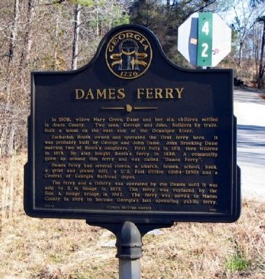
Dames Ferry
Zachariah Booth owned and operated the first ferry here. It was probably built by George and John Dame. John Brooking Dame married two of Booth's daughters. First Polly in 1811, then Mildred in 1815. He also bought Booth`s Ferry in 1838. A community grew up around this ferry and was called "Dames Ferry."
Dames Ferry had several stores, a church, homes, school, bank, a grist and planer mill, a U.S. Post Office (1884-1958) and a Central of Georgia Railroad depot.
The ferry and a fishery was operated by the Dames until it was sold to S.M. Hodge in 1872. The ferry was replaced by Sam A. Hodge bridge in 1962. The ferry was moved to Macon County in 1964 to become Georgia's last operating public ferry.
Erected 1986 by Georgia Department of Natural Resources. (Marker Number 102-9.)
Topics and series. This historical marker is listed in these topic lists: Bridges & Viaducts • Industry & Commerce • Settlements & Settlers • Waterways & Vessels. In addition, it is included in the Georgia Historical Society series list. A significant historical year for this entry is 1808.
Location. 33° 1.518′ N, 83° 44.279′ W. Marker is in Dames Ferry, Georgia, in Monroe County. Marker is at the intersection of Dames Ferry Road (Georgia Route 18) and Old Dames Ferry Road (County Route 42), on the left when traveling east on Dames Ferry Road. Touch for map. Marker is in this post office area: Juliette GA 31046, United States of America. Touch for directions.
Other nearby markers. At least 8 other markers are within 11 miles of this marker, measured as the crow flies. Planter’s Academy (approx. 8.1 miles away); The Stoneman Raid (approx. 8.4 miles away); Sunshine Church (approx. 9.1 miles away); Sunshine Church II (approx. 9.1 miles away); Clinton Methodist Church (approx. 10.4 miles away); Wesleyan College Historic District (approx. 10.4 miles away); The Candler Building (approx. 10˝ miles away); Samuel Griswold (approx. 10.6 miles away).
Credits. This page was last revised on January 31, 2020. It was originally submitted on August 9, 2008, by David Seibert of Sandy Springs, Georgia. This page has been viewed 3,743 times since then and 65 times this year. Photos: 1. submitted on August 9, 2008, by David Seibert of Sandy Springs, Georgia. 2. submitted on January 27, 2011, by David Seibert of Sandy Springs, Georgia. • Craig Swain was the editor who published this page.
Editor’s want-list for this marker. Photo of the bridge which replaced the ferry. • Photo of the ferry site (boat ramp). • Can you help?

