Amador City in Amador County, California — The American West (Pacific Coastal)
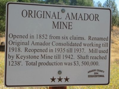
Original Amador Mine
Erected 2004 by Amador County 2004 Sesquicentennial. (Marker Number 14.)
Topics and series. This historical marker is listed in these topic lists: Industry & Commerce • Natural Resources. In addition, it is included in the California - Sutter Creek Gold Mine Trail series list. A significant historical year for this entry is 1852.
Location. 38° 25.192′ N, 120° 49.425′ W. Marker is in Amador City, California, in Amador County. Marker is at the intersection of East School Street and Amador Creek Street, on the right when traveling south on East School Street. Touch for map. Marker is in this post office area: Amador City CA 95601, United States of America. Touch for directions.
Other nearby markers. At least 8 other markers are within 2 miles of this marker, measured as the crow flies. Amador City Cemetery (about 400 feet away, measured in a direct line); Imperial Hotel (about 500 feet away); Keystone Mine (approx. 0.2 miles away); Bunker Hill Mine (approx. 0.3 miles away); South Spring Hill Mine (approx. half a mile away); Treasure Mine (approx. ¾ mile away); Fremont-Gover Mine (approx. 1.2 miles away); New Chicago (approx. 1.4 miles away). Touch for a list and map of all markers in Amador City.
Also see . . . Amador City History. (Submitted on August 17, 2008, by Syd Whittle of Mesa, Arizona.)
Credits. This page was last revised on June 16, 2016. It was originally submitted on August 16, 2008, by Syd Whittle of Mesa, Arizona. This page has been viewed 1,936 times since then and 17 times this year. Photos: 1, 2. submitted on August 16, 2008, by Syd Whittle of Mesa, Arizona. 3. submitted on February 2, 2009. • Craig Swain was the editor who published this page.


