Near Montpelier in Bear Lake County, Idaho — The American West (Mountains)
Halfway House
(Crow Creek Road)
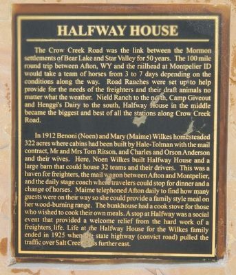
The Crow Creek Road was the link between the Mormon settlements of Bear Lake and Star Valley for 50 years. The 100-mile round trip between Afton, WY and the railhead at Montpelier ID would take a team of horses from 3 to 7 days depending on the conditions along the way. Road Ranches were set up to help provide for the needs of the freighters and their draft animals no matter what the weather. Nield Ranch to the north, Camp Giveout and Henggi’s Dairy to the south, Halfway House in the middle became the biggest and best of all the stations along Crow Creek Road.
In 1912 Benoni (Noen) and Mary (Maime) Wilkes homesteaded 322 acres where cabins had been built by Hale-Tolman with the mail contract, (held by) Mr and Mrs Tom Ritson, and Charles and Orson Anderson and their wives. Here, Noen Wilkes built Halfway House and a large barn that could house 32 teams and their drivers. This was a haven for freighters, the mail wagon between Afton and Montpelier, and the daily stage coach where travelers could stop for dinner and a change of horses. Maime telephoned Afton daily to find how many guests were on their way so she could provide a family style meal on her wood-burning range. The bunkhouse had a cook stove for those who wished to cook their own meals. A stop at Halfway was a social event that provided a welcome relief from the hard work of a freighters life. Life at the Halfway House for the Wilkes family ended in 1925 when the state highway (convict road) pulled the traffic over Salt Creek Pass further east.
Erected 2010 by Star Valley Historical Society.
Topics. This historical marker is listed in these topic lists: Industry & Commerce • Roads & Vehicles. A significant historical year for this entry is 1879.
Location. 42° 30.18′ N, 111° 9.492′ W. Marker is near Montpelier, Idaho, in Bear Lake County. Marker is on Crow Creek Road (Forest Road 111) near Forest Road 147, on the left when traveling north. Touch for map. Marker is in this post office area: Montpelier ID 83254, United States of America. Touch for directions.
Other nearby markers. At least 8 other markers are within 15 miles of this marker, measured as the crow flies. Beaver Divide (approx. one mile away); White Dugway (approx. 2½ miles away); Nield Ranch (approx. 5.4 miles away); Camp Giveout (approx. 6.2 miles away); Snowslide Canyon and Hanke’s Ranch (approx. 7.6 miles away); Old Tithing Office (approx. 14.4 miles away); Pioneer Church (approx. 14.7 miles away); Bank Robbers (approx. 14.9 miles away). Touch for a list and map of all markers in Montpelier.
Regarding Halfway House. For nearly five decades, the (40-mile) Crow Creek Road served as the main link in and out of Star Valley. Starting in 1879 the route was used by Star Valley’s first settlers. Later the road proved to be vital route for commerce between the rail lines in Montpelier and the families that now called Star Valley their home. Crow Creek Road was used extensively until a new road was built over the Salt River Pass...connecting Star Valley to rail lines in Cokeville. -- Star Valley Independent
Also see . . . Experience the Oregon Trail in Idaho. Visit Idaho website entry (Submitted on March 26, 2024, by Larry Gertner of New York, New York.)
Credits. This page was last revised on March 26, 2024. It was originally submitted on July 21, 2017, by Barry Swackhamer of Brentwood, California. This page has been viewed 882 times since then and 49 times this year. Photos: 1, 2, 3. submitted on July 21, 2017, by Barry Swackhamer of Brentwood, California.


