Eatonton in Putnam County, Georgia — The American South (South Atlantic)
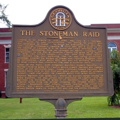
The Stoneman Raid
Clear of the field, both brigades marched toward Eatonton. At Murder Creek (8 miles SW), Capron moved toward Madison and camped north of the Monticello road. Adams continued toward Eatonton, but paused here only to loot food and grain stocks, aware of probable pursuit. Late that night, he camped about five miles north.
Beyond Madison (22 miles N), where he burned large stocks of army supplies, he was joined next afternoon by Capron, who had marched via Rutledge (9 miles W of Madison). They made camp “twelve miles from the bridge crossing the Oconee River, near Athens.” Separated near Athens, Adams reached the Union lines safely; but Capron, resting for two hours near Winder, was surprised before dawn on August 3rd and lost his entire command.
Erected 1957 by Georgia Historical Commission. (Marker Number 117-5.)
Topics and series. This historical marker is listed in this topic list: War, US Civil. In addition, it is included in the Georgia Historical Society series list. A significant historical month for this entry is July 1864.
Location. 33° 19.565′ N, 83° 23.355′ W. Marker is in Eatonton, Georgia, in Putnam County. Marker is on West Marion Street (Georgia Route 16) 0.1 miles west of South Jefferson Avenue (Business U.S. 441), on the right when traveling east. The marker stands on the lawn of the Putnam County Courthouse. Touch for map. Marker is in this post office area: Eatonton GA 31024, United States of America. Touch for directions.
Other nearby markers. At least 8 other markers are within walking distance of this marker. Putnam County (a few steps from this marker); Putnam County Court House (a few steps from this marker); Putnam County Confederate Monument (within shouting distance of this marker); The March to the Sea (within shouting distance of this marker); Putnam County Veterans Monument (within shouting distance of this marker); Veterans Flagpole
(within shouting distance of this marker); Branch Bank of the State of Georgia at Eatonton (about 400 feet away, measured in a direct line); Childhood Home of Joel Chandler Harris (about 500 feet away). Touch for a list and map of all markers in Eatonton.
More about this marker. The marker is numbered 117-5 in error; it appears on state records as 117-6.
Credits. This page was last revised on August 9, 2017. It was originally submitted on August 19, 2010, by David Seibert of Sandy Springs, Georgia. This page has been viewed 892 times since then and 22 times this year. Last updated on August 8, 2017, by Caroline Mitchell Carrico of Memphis, Tennessee. Photos: 1, 2. submitted on August 19, 2010, by David Seibert of Sandy Springs, Georgia. • Bernard Fisher was the editor who published this page.

