Big Rapids in Mecosta County, Michigan — The American Midwest (Great Lakes)
Historic Downtown
Big Rapids
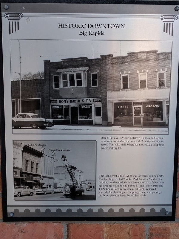
Upper Image Caption
Don's Radio & T.V. and Lutzke's Pianos and Organs were once located on the west side Michigan Avenue, across from City Hall, where we now have a shopping center parking lot.
Lower Image Caption
This is the west side of Michigan Avenue looking north. The building labeled "Pocket Park location" and all the buildings to the north were taken out as part of the urban renewal project in the mid 1960's. The Pocket Park and 1st National Bank (now Chemical Bank) replaced several older buildings; a shopping center and parking lot followed soon thereafter further north.
Topics. This historical marker is listed in this topic list: Industry & Commerce.
Location. 43° 41.949′ N, 85° 28.911′ W. Marker is in Big Rapids, Michigan, in Mecosta County. Marker is on North Michigan Avenue north of Maple Street (State Highway 20), on the right when traveling north. Touch for map. Marker is at or near this postal address: 120 North Michigan Avenue, Big Rapids MI 49307, United States of America. Touch for directions.
Other nearby markers. At least 8 other markers are within walking distance of this marker. A different marker also named Historic Downtown (within shouting distance of this marker); Ferris State College (within shouting distance of this marker); Nisbett Block (about 300 feet away, measured in a direct line); Fairman Building (about 300 feet away); a different marker also named Historic Downtown (about 400 feet away); a different marker also named Historic Downtown (about 400 feet away); a different marker also named Historic Downtown (about 600 feet away); a different marker also named Historic Downtown (approx. 0.2 miles away). Touch for a list and map of all markers in Big Rapids.
Credits. This page was last revised on August 14, 2017. It was originally submitted on August 14, 2017, by Joel Seewald of Madison Heights, Michigan. This page has been viewed 155 times since then and 15 times this year. Photos: 1, 2, 3. submitted on August 14, 2017, by Joel Seewald of Madison Heights, Michigan.


