Covington in Alleghany County, Virginia — The American South (Mid-Atlantic)
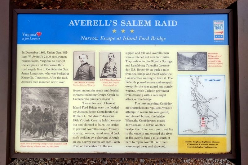
Averellís Salem Raid
Narrow Escape at Island Ford Bridge
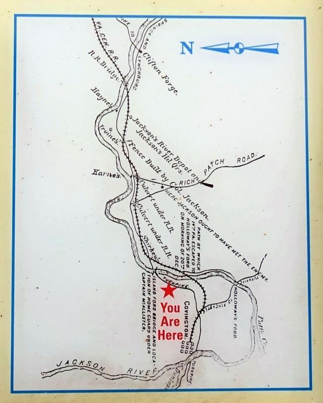
Two miles east of here at Island Ford Bridge over the flooded, icy Jackson River, Confederate Col. William L. “Mudwall” Jacksonís 19th Virginia Cavalry held the crossing and planned to burn the bridge to prevent Averellís escape. Averellís cavalry, however, raced around Jacksonís position by a shortcut through an icy, narrow ravine off Rich Patch Road on December 19. Horses slipped and fell, and Averellís men were stretched out over four miles. They rode onto the Dibrellís Springs and Lynchburg Turnpike (present-day U.S. Route 60) at dusk a mile from the bridge and swept aside the Confederates waiting to burn it. The Federals poured across and escaped, except for the rear guard and supply wagons, which Jackson prevented from crossing with a rare night attack on the bridge.
The next morning, Confederate sharpshooters repulsed Averellís attempt to rescue his rear guard, and Averell burned the bridge. When the Confederates moved downstream to defend another bridge, the Union rear guard set fire to the wagons and crossed the river at Hollowayís Ford a mile south of here to rejoin Averell. Four men were swept away and drowned.
(sidebar)
Visit the Alleghany Highlands Chamber of Commerce & Tourism website at www.visitalleghanyhighlands.com
(captions)
Union cavalry crossing Craigís Creek ten miles south of here, Harperís Weekly, Jan. 16. 1864 issue.
Gen. William W. Averell Courtesy Library of Congress
Col. William L. Jackson Courtesy West Virginia University Library
Island Ford Bridge, view of replacement covered bridge Courtesy Alleghany Historical Society
Erected by Virginia Civil War Trails.
Topics and series. This historical marker is listed in these topic lists: Bridges & Viaducts • War, US Civil. In addition, it is included in the Virginia Civil War Trails series list. A significant historical date for this entry is December 19, 1863.
Location. 37° 46.307′ N, 79° 57.995′ W. Marker is in Covington, Virginia, in Alleghany County. Marker is on Mall Road, 0.2 miles east of Horse Mountain View (Virginia Route 648), on the left when traveling east. Located outside the Alleghany Highlands Chamber of Commerce & Tourism Visitors Center in the Mallow Mall Shopping Center. Touch for map. Marker is at or near this postal address: 110 Mall Rd, Covington VA 24426, United States of America. Touch for directions.
Other nearby markers. At least 8 other markers are within 6 miles of this marker, measured as the crow flies. Fort Young (approx. 1.4 miles away); Alleghany's Heroic Dead (approx. 2.1 miles away); a different marker also named Alleghany's Heroic Dead (approx. 2.1 miles away); Alleghany's Heroic Dead. (approx. 2.1 miles away); Alleghany County Confederate Soldiers Monument (approx. 2.1 miles away); Low Moor Iron Company Coke Ovens (approx. 4.7 miles away); Humpback Bridge (approx. 4.8 miles away); The Road to the Kanawha (approx. 5.8 miles away). Touch for a list and map of all markers in Covington.
Also see . . . Alleghany Highlands of Virginia. Alleghany Highlands Chamber of Commerce & Tourism (Submitted on September 5, 2017.)
Credits. This page was last revised on September 7, 2017. It was originally submitted on September 5, 2017, by Bernard Fisher of Richmond, Virginia. This page has been viewed 964 times since then and 67 times this year. Photos: 1, 2, 3, 4. submitted on September 5, 2017, by Bernard Fisher of Richmond, Virginia.


