Near Pierre in Hughes County, South Dakota — The American Midwest (Upper Plains)
The Oahe Dam & Lake
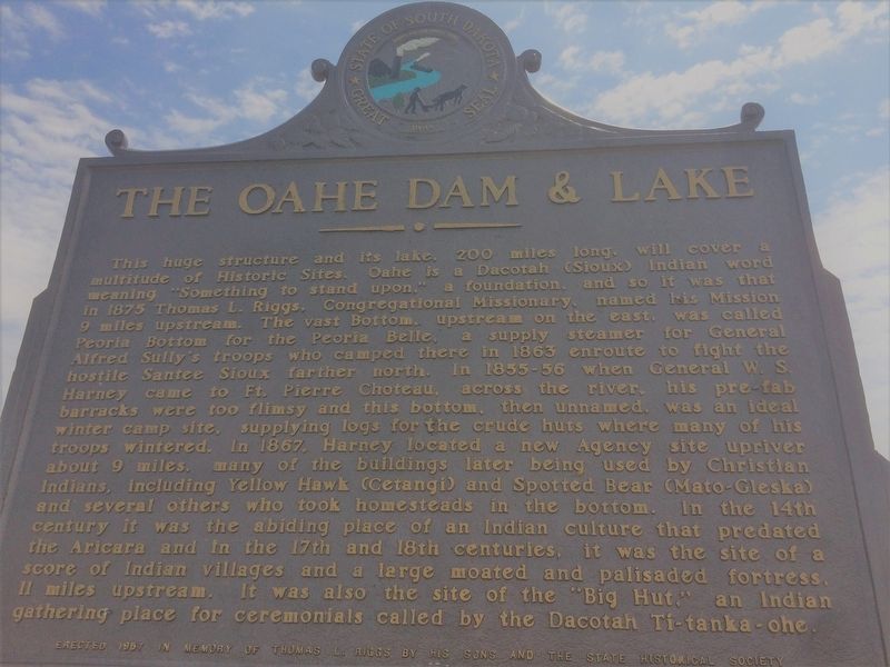
This huge structure and its lake, 200 miles long, will cover a multitude of Historic Sites. Oahe is a Dacotah (Sioux) Indian word meaning "Something to stand upon," a foundation, and so it was that in 1875 Thomas L. Riggs, Congregational Missionary, named his Mission 9 miles upstream. The vast Bottom, upstream on the east, was called Peoria Bottom for the Peoria Belle, a supply steamer for General Alfred Sully's troops who camped there in 1863 enroute to fight the hostile Santee Sioux farther north. In 1855-56 when General W. S. Harney came to Ft. Pierre Choteau, across the river, his pre-fab barracks were too flimsy and this bottom, then unnamed, was an ideal winter camp site, supplying logs for the crude huts where many of his troops wintered. In 1867, Harney located a new Agency site upriver about 9 miles, many of the buildings later being used by Christian Indians, including Yellow Hawk (Cetangi) and Spotted Bear (Mato-Gleska) and several others who took homesteads in the bottom. In the 14th century it was the abiding place of an Indian culture that predated the Aricara and in the 17th and 18th centuries, it was the site of a score of Indian Villages and a large moated and palisaded fortress, 11 miles upstream. It was also the site of the "Big Hut," an Indian gathering place for ceremonials called by the Dacotah Ti-tanka-ohe.
Reverse
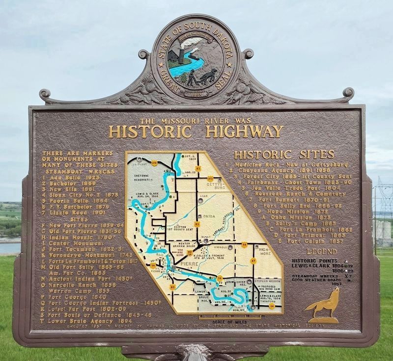
Historic Highway
There are markers or monuments at many of these sites.
Steamboat Wrecks
1 Ada Belle 1923
2 Bachelor 1869
3 New Elia 1881
4 Sioux City No. 2 1873
5 Peoria Belle 1864
6 F. Y. Batchelor 1879
7 Lizzie Reed 1901
Sites
F New Fort Pierre 1859-64
G Old Fort Pierre 1831-56
H Indian Mosaic 1780?
I Center Monument
J Fort Tecumseh 1822-31
K Verendrye Monument 1743
L Forts La Frambois I & Teton 1817
M Old Fort Sully 1863-66
Am. Fur Co. 1863
N Ancient Indian Fort 1450?
O Narcelle Ranch 1856
Warren Camp 1855
P Fort George 1840
Q Fort George Indian Fortress 1450?
R Loisel Fur Post 1802-09
S Fort Bouis or Defiance 1845-46
T Lower Brule Agency 1894
Historic Sites
1 Medicine Rock - Now at Gettysburg
2 Cheyenne Agency 1891-1958
3 Forest City 1883 - 1st County Seat
4 Fairbanks - Ghost Town 1883-90
5 Jon Valle Trade Post 1804
6 Rousseau Ranch & Cemetery
7 Fort Bennett 1870-91
8 Fort Sully 2nd 1866-92
9 Hope Mission 1872
A Oahe Mission 1873
B Sully's Camp 1863
C Fort La Frambois 1862
D Fort Primeau 1863
E Fort Galpin 1857
Erected 1957 by the State Historical Society and the sons of Thomas L. Riggs, in memory of Thomas L. Riggs. (Marker Number 221.)
Topics and series. This historical marker is listed in these topic lists: Churches & Religion • Native Americans • Settlements & Settlers. In addition, it is included in the South Dakota State Historical Society Markers series list. A significant historical year for this entry is 1875.
Location. 44° 26.646′ N, 100° 22.531′ W. Marker is near Pierre, South Dakota, in Hughes County. Marker is on State Highway 1804, 1.8 miles west of Grey Goose Rd, on the left when traveling north. Touch for map. Marker is in this post office area: Pierre SD 57501, United States of America. Touch for directions.
Other nearby markers. At least 8 other markers are within 2 miles of this marker, measured as the crow flies. A Changing Landscape (a few steps from this marker); The Lewis and Clark Expedition (within shouting distance of this marker); A Tense Three Days (within shouting distance of this marker); Sioux Indian Mosaic (approx. 0.9 miles away); Turtle Effigy (approx. 0.9 miles away); Oahe Mission (approx. 1.1 miles away); Oahe Mission School and Chapel (approx. 1.1 miles away); Stilling Basin (approx. 1.8 miles away). Touch for a list and map of all markers in Pierre.
Credits. This page was last revised on May 19, 2023. It was originally submitted on January 17, 2018, by Ruth VanSteenwyk of Aberdeen, South Dakota. This page has been viewed 222 times since then and 30 times this year. Photos: 1. submitted on January 17, 2018, by Ruth VanSteenwyk of Aberdeen, South Dakota. 2, 3. submitted on May 19, 2023. 4. submitted on January 18, 2018, by Ruth VanSteenwyk of Aberdeen, South Dakota. • Bill Pfingsten was the editor who published this page.


