Fredericksburg, Virginia — The American South (Mid-Atlantic)
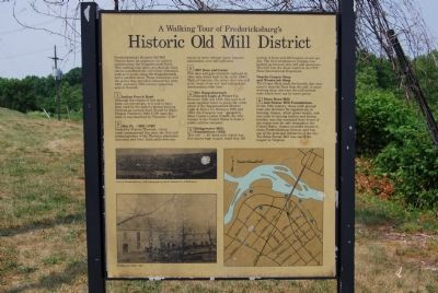
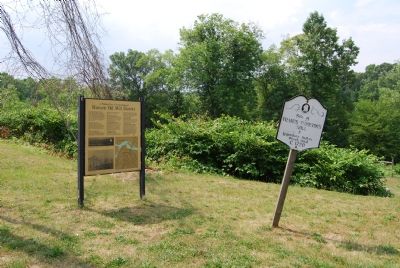
A Walking Tour of Fredericksburg’s Historic Old Mill District
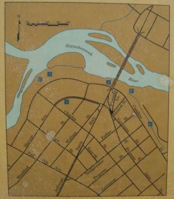
Fredericksburg’s Historic Old Mill District dates its origins to the earliest settlers along the Rappahannock River. This walking tour takes you through what can be considered the city’s first industrial park as it winds along the Rappahannock and a parallel canal. These waterways and the power they provided allowed this 18th, 19th, and early 20th century industrial area to flourish.
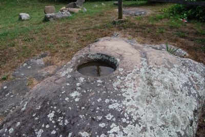
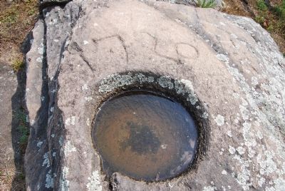
1. Indian Punch Bowl
Although the origins of this stone basin are not certain, it is said to have been used by the Indians during hunting festivals as a punch bowl. Found by Major Francis Thornton (1682-1758) upon his land, it was inscribed by Thornton “1720.”
2. Site First Mill (1720)
Owned by Francis Thornton, whose lands encompassed this area, the first mill ground produce of the the Thornton plantation into meal and flour . Such mills were necessary in early colonial times, because plantations were self-sufficient.
3. 1907 Dam and Gates
This dam and gate structure replaced an older dam dated back to the early 1800’s. Made of concrete, the newer dam was said to be “State of the art” and replaced the deteriorating older dam.
4. Site Rappahannock Electric Light & Power Company
Between 1822 and 1922, this section of canal supplied water to power the water wheel of the Rappahannock Electric Light & Power Co. Between 1900 and 1923, the Company was managed by Ellen Caskie London Ficklin, the first woman in the United States to head a public utilities company.
5. Bridgewater Mills Foundations (1822)
This 150’ x 40’ brick mill, which was five stories high in part, could ship 150 barrels of flour and 400 bushels of corn per day. The first telephone in Virginia was hooked up between this mill and downtown. The mill won the silver medal at the 1878 Paris International Exposition. Nearby Cooper Chop and Woodwork Shop The Cooper Shop made barrels that were used to ship the flour from the mill. A wood-working shop, also near the mill, utilized tools which were run by water power.
6. Knox Bone Mill and Sumac Mill Foundations
In the 19th century, these mills ground bone into fertilizer for regional use in farming, Sumac, which grows locally, and was used in tanning leather and dyeing textiles, was also extracted from leaves of the sumac tree for sale throughout the United States. Sumac provided income to many Fredericksburg citizens and was one of the principal industries of the city. The Knox Sumac Mill was one of the largest in Virginia.
Topics. This historical marker is listed in this topic list: Industry & Commerce. A significant historical year for this entry is 1720.
Location. Marker is missing. It was located near 38° 19.18′ N, 77° 28.528′ W. Marker was in Fredericksburg, Virginia. Marker was at the intersection of Riverside Drive and Charles Street on Riverside Drive. Touch for map. Marker was in this post office area: Fredericksburg VA 22401, United States of America. Touch for directions.
Other nearby markers. At least 10 other markers are within walking distance of this location. Contact: An Industrial Society Confronts A Native American Culture (a few steps from this marker); Harnessing The River's Power (within shouting distance of this marker); Amoroleck Encounters John Smith (about 500 feet away, measured in a direct line); Veterans of Foreign Wars Eternal Flame (approx. ¼ mile away); Killed in Action Memorials (approx. ¼ mile away); Transportation and Settlement (approx. ¼ mile away); Capt. John Smith (approx. ¼ mile away); Gari Melchers Home and Studio (approx. 0.3 miles away); Bound for Freedom (approx. 0.3 miles away); A History of Floods (approx. 0.3 miles away). Touch for a list and map of all markers in Fredericksburg.
Related markers. Click here for a list of markers that are related to this marker. To better understand the relationship, study each marker in the order shown.
Also see . . .
1. Walk Through History . . . Mill Sites and Water Power. (Submitted on June 2, 2007, by Dawn Bowen of Fredericksburg, Virginia.)
2. Germania Mill Blaze. (Submitted on June 6, 2007, by Dawn Bowen of Fredericksburg, Virginia.)
Credits. This page was last revised on February 2, 2023. It was originally submitted on June 2, 2007, by Dawn Bowen of Fredericksburg, Virginia. This page has been viewed 1,929 times since then and 20 times this year. Last updated on June 10, 2007, by Dawn Bowen of Fredericksburg, Virginia. Photos: 1. submitted on June 2, 2007, by Dawn Bowen of Fredericksburg, Virginia. 2, 3, 4, 5. submitted on June 4, 2007, by Dawn Bowen of Fredericksburg, Virginia. • J. J. Prats was the editor who published this page.
