Cheyenne in Laramie County, Wyoming — The American West (Mountains)
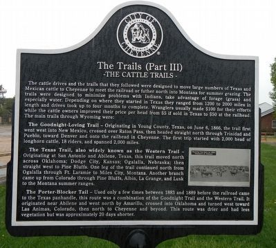
The Trails (Part III)
The cattle drives and the trails that they followed were designed to move large numbers of Texas and Mexican cattle to Cheyenne to meet the railroad or further north into Montana for summer grazing. The trails were designed to minimize problems with Indians, take advantage of forage (grass) and especially water. Depending on where they started in Texas they ranged from 1200 to 2000 miles in length and drives took up to four months to complete. Wranglers usually made $100 of their efforts while the cattle owners improved prices per head from $5 if sold in Texas to $50 at the railhead. The main trails through Wyoming were:
The Goodnight-Loving Trail - Originating in Young County, Texas, on June 6, 1866, the trail first went west into New Mexico, crossed over Raton Pass, then headed straight north through Trinidad and Pueblo, toward Denver and onto the railhead in Cheyenne. The first trip started with 2,000 head of longhorn cattle, 18 riders, and spanned 2,000 miles.
The Texas Trail, also widely known as the Western Trail - Originating at San Antonio and Abilene, Texas, this trail moved north across Oklahoma; Dodge City, Kansas; Ogalalla, Nebraska; then straight west to Pine Bluffs. One leg of the trail continued north from Ogalalla through Ft. Laramie to Miles City, Montana. Another branch came up from Colorado through Pine Bluffs, Albin, La Grange, and Lusk to the Montana summer ranges.
The Porter-Blocker Tail (sic) - Used only a few times between 1883 and 1889 before the railroad came to the Texas panhandle, this route was a combination of the Goodnight Trail and the Western Trail. It originated near Abilene and went north by Amarillo, crossed into Oklahoma and turned west toward Las Animas, Colorado, then north to Cheyenne and beyond. This route was drier and had less vegetation but was approximately 20 days shorter.
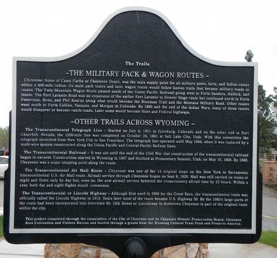
Cheyenne, home of Camp Carlin or Cheyenne Depot, was the main supply point for all military post, forts, and Indian camps within a 400-mile radius. Its mule pack trains and later wagon trains would follow known trails that became military roads or routes. The Twin Mountain Wagon Route passed south of the Union Pacific Railroad going west to Forts Sanders, Halleck, and Steele. The Fort Laramie Road was an expansion the earlier Fort Laramie to Denver Stage route but continued north to Forts Fetterman, Reno, and Phil Kearny along what would become the Bozeman Trail and the Montana Military Road. Other routes went south to Forts Collins, Vasquez, and Morgan in Colorado. By 1890 and the end of the Indian Wars, many of these routes would disappear or become ranch roads. Later, some would become State and Federal highways.
The Transcontinental Telegraph Line - Started on July 4, 1861 in Julesburg, Colorado and on the other end at Fort Churchill, Nevada: the 1200-mile line was completed on October 26, 1861 at Salt Lake City, Utah. With this connection the telegraph stretched from New York City to San Francisco. The telegraph line operated until May 1969, when it was replaced by a multi-wire system constructed along the Union and Central Pacific Railway lines.
The Transcontinental Railroad - It was not until the end of the Civil War that construction of the transcontinental railroad began in earnest. Construction stared in Wyoming in 1867 and finished at Promontory Summit, Utah, on May 10, 1869. By 1868, Cheyenne was a major stopping point along the route.
The Transcontinental Air Mail Route - Cheyenne was one of the 14 original stops on the New York to Sacramento transcontinental U.S. Air Mail route. Airmail service through Cheyenne began on Sept. 8, 1920. Mail was still carried on trains at night and flown only by day but, even so, the new airmail service bettered the cross-country all-rail time by 22 hours. Within a year, both day and night flights would commence.
The Transcontinental or Lincoln Highway - Although first used in 1908 for the Great Race, the transcontinental route was officially called the Lincoln Highway in 1913. Years later most of the route became U.S. Highway 30. By the 1960's large parts of the route had been incorporated into Interstate 80. 16th Street or Lincolnway in downtown Cheyenne is part of the original route within the city.
Erected by City of Cheyenne, Cheyenne Historic Historic Preservation Board, Cheyenne Area Convention and Visitors Board, Wyoming Cultural Trust Fund and Preserve America.
Topics. This historical marker is listed in these topic lists: Industry & Commerce • Military • Roads & Vehicles.
Location. 41° 9.45′ N, 104° 50.029′ W. Marker is in Cheyenne, Wyoming, in Laramie County. Marker can be reached from Carey Avenue near Lions Park Drive. Touch for map. Marker is at or near this postal address: 4610 Carey Avenue, Cheyenne WY 82001, United States of America. Touch for directions.
Other nearby markers. At least 8 other markers are within walking distance of this marker. Cheyenne Frontier Days™ (Part I) (within shouting distance of this marker); Cheyenne Frontier Days™ (Part II) (within shouting distance of this marker); The Trails (Part I) (within shouting distance of this marker); The Trails (Part II) (within shouting distance of

Photographed By Barry Swackhamer, May 27, 2016
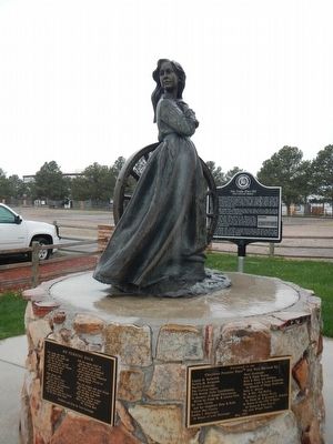
4. No Turning Back, sculpture and poem by Veryl Goodnight
Too young and naive to think they could fail
Too full of visions for the end of the trail
They stored their silk dresses and donned calico
To join the cry of Westward Ho
Their diaries tell of the endless hours
The vast sea of grass and bounty of wildflowers
They tell of children conceived and born
And of those who were buried in the gray silent morn
Still the wagons rolled on and the ruts got deeper
The column moved westward as the route got steeper
Teams dropped from exhaustion in the summer heat
As the emigrants pressed on defying defeat
They met Indians who were friends and many that were foe
They saw days of drought and blinding snow
Only one thing was certain along this wagon track
There was absolutely No Turning Back
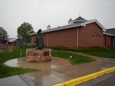
More about this marker. This marker is located in front of the Cheyenne Frontier Days/Old West Museum.
Also see . . . The Goodnight-Loving Trail - Legends of America. Goodnight, a former Texas Ranger and Indian Scout met pioneer cowboy, Oliver Loving sometime after the Civil War. At this time, the cattle markets were inadequate for the available cattle and the two wanted to capitalize on the need for cattle at Fort Sumner, New Mexico, where some 8,000 Navajo had been settled at the Bosque Redondo reservation. Bad planning by the government for provisions at the reservation led to an urgent need for food supplies. (Submitted on June 14, 2016, by Barry Swackhamer of Brentwood, California.)
Credits. This page was last revised on February 8, 2018. It was originally submitted on June 14, 2016, by Barry Swackhamer of Brentwood, California. This page has been viewed 424 times since then and 16 times this year. Last updated on February 7, 2018, by Douglass Halvorsen of Klamath Falls, Oregon. Photos: 1, 2, 3, 4. submitted on June 14, 2016, by Barry Swackhamer of Brentwood, California.


