Lehigh Township near Weatherly in Carbon County, Pennsylvania — The American Northeast (Mid-Atlantic)
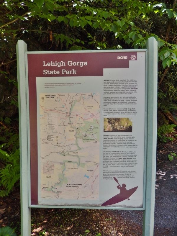
Lehigh Gorge State Park
One way to experience the park is through whitewater boating. Rafters, kayakers and canoeists enjoy Class II and III rapids throughout the gorge. Licensed whitewater outfitters are available. Scheduled water releases from Francis E. Walter Dam normally provide adequate water levels.
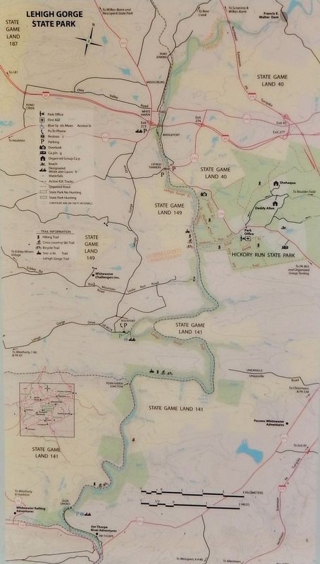
The over 20-mile non-motorized Lehigh Gorge Trail provides hikers, bikers, wildlife watchers, hunters and anglers access to the park. In winter, 15 miles are open to snowmobiles and more than 20 miles to cross-country skiers.
History enthusiasts will also find the park rich in resources. In the early 1800s, famed naturalist John James Audubon visited the gorge to paint birds. He heard the sounds of the crosscut saw as lumbermen fell huge trees and logs were floated as far south as Philadelphia. By 1841, sawmills dotted the landscape between White Haven and Mauch Chunk (present-day Jim Thorpe) and provided lumber for mine supports and canal boats.
The discovery of anthracite coal nearby in 1791 fueled the need for a transportation system to haul coal and goods to markets in the south. Josiah White, co-founder of the Lehigh Coal and Navigation Company, hired Edwin A. Douglas to construct the ”Upper Grand Section” of the Lehigh Canal. This slackwater navigation system overcame a 600-foot drop in elevation from White Haven to Mauch Chunk by using mules to pull canal boats through 29 locks and 20 dams. When a flood severely damaged the canal in 1862, it was abandoned in favor of more efficient railroads.
Where hundreds once labored, thousands now recreate. Remnants and reminders of these early industries dot the gorge. Wayside exhibits remind us of the past by highlighting historical events. Lehigh Gorge State Park is located in the Delaware and Lehigh National Heritage Corridor.
Erected by Pennsylvania Department of Conservation and Natural Resources and Delaware & Lehigh National Heritage Corridor.
Topics and series. This historical marker is listed in these topic lists: Industry & Commerce • Parks & Recreational Areas • Settlements & Settlers • Waterways & Vessels. In addition, it is included in the Lehigh Canal series list.
Location. 40° 57.973′ N, 75° 45.286′ W. Marker is near Weatherly, Pennsylvania, in Carbon County. It is in Lehigh Township. Marker can be reached from Rockport Road, one mile east of South Lehigh Gorge Drive. Marker is located along the Lehigh Gorge Trail (Delaware and Lehigh Trail), in Lehigh Gorge State Park, near the Rockport trailhead and parking lot. Touch for map. Marker is in this post office area: Weatherly PA 18255, United States of America. Touch for directions.
Other nearby markers. At least 8 other markers are within 4 miles of this marker, measured as the crow flies. Audubon Spoke for the Trees (here, next to this marker); From Rails to Trails (within shouting distance of this marker); Railroad Intersection (approx. 1½ miles away); Engineering Marvel (approx. 2.6 miles away); A Revolution in Canal Technology (approx. 2.6 miles away); Disaster at Mud Run (approx. 2.6 miles away); a different marker also named A Revolution in Canal Technology (approx. 4.1 miles away); Pioneer Pipeline (approx. 4.1 miles away). Touch for a list and map of all markers in Weatherly.
Also see . . .
1. History of Lehigh Gorge State Park
.
Settlement was sparse during the 19th century until loggers arrived and began felling trees and building sawmills. The discovery of anthracite coal at Summit Hill in 1791 caused intensive development and settlement of the upper Lehigh Valley. During the early 1800s, the need to transport increasingly large quantities of coal to markets down river led to the intensive development of canals. Between 1835 and 1838, a series of dams, locks, and canals was constructed by Josiah White and the Lehigh Coal and Navigation Company.(Submitted on March 4, 2018, by Cosmos Mariner of Cape Canaveral, Florida.)
2. Lehigh Gorge State Park (Wikipedia).
The history of Lehigh Gorge State Park is tied into the development of anthracite coal mining, which was once the center of the high-tech economy of northeastern Pennsylvania in its day. It is also tied into the early-to-middle period of the United State's Canal Era and the rapid development of pragmatic railroading technologies and consequent accelerated growth and use of railroads—all contributing factors in the Pennsylvanian and North American Industrial Revolution. By the 1790s deforestation of the American East was making the search for alternative fuels urgent and many were willing to invest in ventures to somehow mine and ship Anthracite east to the Delaware River where it could be barged to the cities of the east coast of the United States.(Submitted on March 4, 2018, by Cosmos Mariner of Cape Canaveral, Florida.)
Credits. This page was last revised on June 10, 2023. It was originally submitted on March 4, 2018, by Cosmos Mariner of Cape Canaveral, Florida. This page has been viewed 238 times since then and 13 times this year. Photos: 1, 2, 3. submitted on March 4, 2018, by Cosmos Mariner of Cape Canaveral, Florida. • Bill Pfingsten was the editor who published this page.


