Memphis in Shelby County, Tennessee — The American South (East South Central)
Ostrica Lock/Buras, Louisiana/Empire Lock/Nairn, Louisiana
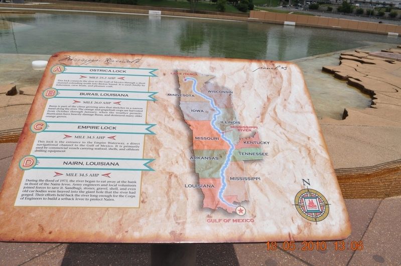
Panel #3 Mississippi Riverwalk
Inscription.
A) Ostrica Lock
Mile 25.2 AHP
This lock connects the river to the Gulf of Mexico through a short channel extending north into Breton Sound. It is used chiefly by fishermen, crew boats, and pleasure craft.
B) Buras, Louisiana
Mile 26.0 AHP
Buras is part of the citrus growing area that stretches in a narrow band along the river. The orange and grapefruit are harvested from October through January when the weather permits. Hurricanes have heavily damage Buras and destroyed many older orange groves.
C) Empire Lock
Mile 34.5 AHP
This lock is the entrance to the Empire Waterway, a direct navigational channel to the Gulf of Mexico. It is primarily used by commercial vessels carrying seafood, shells, and offshore drilling equipment.
D) Nairn, Louisiana
Mile 34.5 AHP
During the flood of 1973, the river began to eat away at the bank in front of the Nairn Levee. Army engineers and local volunteers joined forces to save it. Sandbags, stones, gravel, shell, and ever old car bodies were heaved into the giant hole that the river had gorged. Their efforts held back the river long enough for the Corps of Engineers to build a setback levee to protect Nairn.
Erected by Mississippi Riverwalk. (Marker Number 3.)
Topics. This historical marker is listed in these topic lists: Disasters • Man-Made Features • Waterways & Vessels. A significant historical year for this entry is 1973.
Location. 35° 8.968′ N, 90° 3.507′ W. Marker is in Memphis, Tennessee, in Shelby County. Marker can be reached from Island Drive, 0.8 miles south of West A.W. Willis Avenue when traveling south. Located in Mud Island River Park. Touch for map. Marker is at or near this postal address: 125 N Front St, Memphis TN 38103, United States of America. Touch for directions.
Other nearby markers. At least 8 other markers are within walking distance of this marker. The Mississippi Riverwalk (here, next to this marker); Ohio River (here, next to this marker); Cairo, Illinois (here, next to this marker); Islands No. 2, 3, and 4 / Fort Jefferson, Kentucky / Bird’s Point, Missouri (here, next to this marker); Island No. 5 (Wolf Island)/Belmont, Missouri/Columbus, Kentucky (here, next to this marker); Donaldson Point, Missouri/Island No. 8/Hickman, Kentucky/Dorena Crevasse (here, next to this marker); New Madrid, Missouri/Cates Casting Field/Island No. 10 (here, next to this marker); Tiptonville, Tennessee/Bixby Towhead (here, next to this marker). Touch for a list and map of all markers in Memphis.
Also see . . .
1. Buras-Triumph, Louisiana. In April 1862, during the American Civil War, the Battle of Forts Jackson and St. Philip took place near Buras. Union Flag Officer David Farragut led a fleet up the river to capture New Orleans and engaged the forts in the early morning hours of April 23. A single Union vessel, the USS Varuna, was sunk near Buras in an engagement with the Confederate steamer CSS Governor Moore and the CSS Stonewall Jackson. The heavily damaged Governor Moore also sank, not far from its Union opponent. (Submitted on March 12, 2018, by Sandra Hughes Tidwell of Killen, Alabama, USA.)
2. LA Hometown Locator. Since Nairn is located within the Empire CDP, all of the census and demographic data for residents of Nairn are included as part of the information reported for Empire CDP in the "Data" tab above. (Submitted on March 12, 2018, by Sandra Hughes Tidwell of Killen, Alabama, USA.)
Credits. This page was last revised on April 15, 2019. It was originally submitted on March 12, 2018, by Sandra Hughes Tidwell of Killen, Alabama, USA. This page has been viewed 495 times since then and 59 times this year. Photo 1. submitted on March 12, 2018, by Sandra Hughes Tidwell of Killen, Alabama, USA. • Bernard Fisher was the editor who published this page.
Editor’s want-list for this marker. Wide shot of marker and its surroundings. • Can you help?
