Memphis in Shelby County, Tennessee — The American South (East South Central)
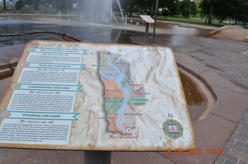
Belle Chasse, Louisiana/English Turn Bend/Caernarvon Crevasse/Poydras Crevasse
Panel #6 Mississippi Riverwalk
Inscription.
A) Belle Chasse, Louisiana
Mile 75.9 AHP
Belle Chasse Plantation was the home of Judah P. Benjamin, often called “the brains of the Confederate government.” He served as Attorney General Secretary of War and Secretary of State for the Confederacy. After the Civil War, he left Belle Chasse, fled to England and never returned.
B) English Turn Bend
Mile 78.0 AHP
Jean Baptiste LeMoyne, Sieur de Bienville, with only a small boat and a few men, encountered a British ship, at this bend in 1699. With convincing authority, the 19-year-old explorer informed the ship’s captain that this was a French River and that a large French force was units way to protect the claim. The English captain swallowed the monumental bluff. He quickly turned his vessel around and sailed for the Gulf. His hasty retreat gave this bend its name.
C) Caernarvon Crevasse
Mile 81.3 AHP
During the flood of 1927, the river again threatened to overtop the New Orleans levee. Authorities decided to blast a hole in the levee down the river at Caernarvon, hoping that this outlet would lower the flood’s height at New Orleans. Caernarvon’s residents were understandably upset with this drastic measure, but the citizens of New Orleans promised to reimburse them for their losses. Several days of dynamiting opened a wide gap which grew to become a half-mile break in the levee. As flood waters poured over Caernarvon, the river at New Orleans fell, sparing the city.
D) Poydras Crevasse
Mile 82.1 AHP
A large group of an immigrant from the Canary Islands settled in this area in the late 1770’s. They used oxen to pull their plows and wagons, and the area became known as “Terre aux Boeufs," meaning Land of Oxen. Poydras was virtually wiped out in 1922 by a large crevasse. This break in the Poydras levee caused the river to fall at New Orleans, where the flood stage had threatened to overflow the levees. Thousands of New Orleans residents drove to Poydras to see the disaster that had saved their city.
Erected by Mississippi Riverwalk. (Marker Number 6.)
Topics. This historical marker is listed in these topic lists: Disasters • Settlements & Settlers • War, US Civil • Waterways & Vessels. A significant historical year for this entry is 1699.
Location. 35° 8.968′ N, 90° 3.507′ W. Marker is in Memphis, Tennessee, in Shelby County. Marker can be reached from Island Drive, 0.8 miles south of West A.W. Willis Avenue when traveling south. Located in Mud Island River Park. Touch for map. Marker is at or near this postal address: 125 N Front Street, Memphis TN 38103, United States of America. Touch for directions.
Other nearby markers. At least 8 other markers are within walking distance of this marker. The Mississippi Riverwalk (here, next to this marker); Ohio River (here, next to this marker); Cairo, Illinois (here, next to this marker); Islands No. 2, 3, and 4 / Fort Jefferson, Kentucky / Bird’s Point, Missouri (here, next to this marker); Island No. 5 (Wolf Island)/Belmont, Missouri/Columbus, Kentucky (here, next to this marker); Donaldson Point, Missouri/Island No. 8/Hickman, Kentucky/Dorena Crevasse (here, next to this marker); New Madrid, Missouri/Cates Casting Field/Island No. 10 (here, next to this marker); Tiptonville, Tennessee/Bixby Towhead (here, next to this marker). Touch for a list and map of all markers in Memphis.
Credits. This page was last revised on March 13, 2018. It was originally submitted on March 12, 2018, by Sandra Hughes Tidwell of Killen, Alabama, USA. This page has been viewed 314 times since then and 22 times this year. Photo 1. submitted on March 12, 2018, by Sandra Hughes Tidwell of Killen, Alabama, USA. • Bernard Fisher was the editor who published this page.
Editor’s want-list for this marker. Wide shot of marker and its surroundings. • Can you help?
