Memphis in Shelby County, Tennessee — The American South (East South Central)
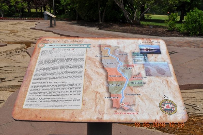
The Atchafalaya Problem
Panel #22
The Threat of drastic change in the Lower Mississippi River channel at the Old River Junction has been the most serious problem in the modern history of the river. The Mississippi once curved westward in this area through Turnbill’s Bend. In 1831, Captain Henry Shreve built a cutoff to bypass the bend, and the potentially disastrous situation began to develop
Two rivers had met the Mississippi at Turnbill’s Bend: The Red River, a tributary of the Mississippi; and the Atchafalaya River, which receives high water overflow from the Mississippi and carries it south to the Gulf of Mexico. After the cutoff, built by Shreve, the Atchafalaya clogged up and when its channel was cleared again it had enlarged greatly. The upper arm of the old bend filled up and the Atchafalaya took the route of the lower arm, known as Old River, as its connection to the Mississippi River Channel. In 1872, the Red River shifted its mouth to flow directly into the Atchafalaya, enlarging it more. For years, water flowed both ways through Old River, depending on the relative river stages of the Red River and the Mississippi River. But by 1880 the Mississippi flowed west into the Atchafalaya at all times. Despite strenuous attempts to limit this flow, it became obvious that if left alone, the Mississippi channel would eventually divert through Old River and flow to the Gulf of Mexico through this Atchafalaya’s channel. New Orleans, Baton Rouge, and all of southern Louisiana’s river industry would be permanently removed from the Mississippi River.
In 1954, after years of study, the Corps of Engineers began a major project to attempt to solve the Atchafalaya problem. By 1963, a huge earthen dam across the Old River’s eastern end had stopped the Mississippi’s flow into the Atchafalaya River. A navigation lock was built to allow river traffic access to the Red River and the Atchafalaya. To handle high water runoff and outflow channel was dredged between the Mississippi River and the Red River several miles north of Old River, and an embankment built to control the flow. The 1973 flood badly damaged the structures and the Mississippi again threatened to divert west.
When the Corps of Engineers has consulted its work on stabilizing the problem at Old River, it will end a struggle between man and the Mississippi that has lasted more than 150 years.
Photo Credit: (1) Atchafalaya Swamp at Sunset, Mike P. Murphy/USACEM (2)The Atchafalaya Basin/USACE, (3) Control Structure, Michael Maples/USACE (Marker Number 22.)
Topics. This historical marker is listed in these topic lists: Disasters • Waterways & Vessels. A significant historical year for this entry is 1831.
Location. 35° 8.968′ N, 90° 3.507′ W. Marker is in Memphis, Tennessee, in Shelby County. Marker is on Riverside Drive. Mud Island Mississippi Riverwalk. Touch for map. Marker is at or near this postal address: 125 N Front St, Memphis TN 38103, United States of America. Touch for directions.
Other nearby markers. At least 8 other markers are within walking distance of this marker. The Mississippi Riverwalk (here, next to this marker); Ohio River (here, next to this marker); Cairo, Illinois (here, next to this marker); Islands No. 2, 3, and 4 / Fort Jefferson, Kentucky / Bird’s Point, Missouri (here, next to this marker); Island No. 5 (Wolf Island)/Belmont, Missouri/Columbus, Kentucky (here, next to this marker); Donaldson Point, Missouri/Island No. 8/Hickman, Kentucky/Dorena Crevasse (here, next to this marker); New Madrid, Missouri/Cates Casting Field/Island No. 10 (here, next to this marker); Tiptonville, Tennessee/Bixby Towhead (here, next to this marker). Touch for a list and map of all markers in Memphis.
Also see . . . America's Achilles' Heel: the Mississippi River's Old River Control Structure. Weather Underground website entry (Submitted on December 13, 2021, by Larry Gertner of New York, New York.)
Credits. This page was last revised on December 13, 2021. It was originally submitted on March 14, 2018, by Sandra Hughes Tidwell of Killen, Alabama, USA. This page has been viewed 346 times since then and 27 times this year. Last updated on April 12, 2018, by T. Patton of Jefferson, Georgia. Photo 1. submitted on March 14, 2018, by Sandra Hughes Tidwell of Killen, Alabama, USA. • Andrew Ruppenstein was the editor who published this page.
