Greene Township near Fayetteville in Franklin County, Pennsylvania — The American Northeast (Mid-Atlantic)
The Good Roads Jubilee / The Lincoln Highway
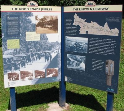
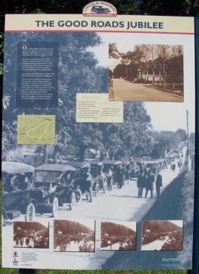
One of the largest celebrations for the opening of a paved section of the Lincoln Highway was held here, at the Caledonia Forest Reserve Park, on October 4, 1921.
The new paved section of the Lincoln Highway stretched from Gettysburg to Chambersburg. It completed a 113-mile triangular paved auto-touring route from the state capital to Gettysburg, then to Chambersburg and back to Harrisburg.
An estimated 30,000 automobiles joined the celebration.
The Great Roads Jubilee Pageant was touted as the world's largest parade showing the evolution of transportation. Even George Washington's coach from Valley Forge was in the parade. Gettysburg and Wilson colleges canceled classes so students could participate. On the reviewing platform, guests from a dozen other state highway commissions joined Lincoln Highway Association members.
(Right Side):
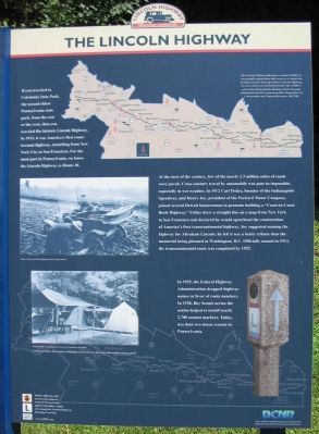
If you traveled to Caledonia State Park, the second oldest Pennsylvania state park, from the east or west, then you traveled the historic Lincoln Highway. In 1913, it was America's first coast-to-coast highway, stretching from New York City to San Francisco. For the most part in Pennsylvania, we know the Lincoln Highway as Route 30.
At the turn of the century, few of the nearly 2.5 million miles of roads were paved. Cross-country travel by automobile was poor to impossible, especially in wet weather. In 1912 Carl Fisher, founder of the Indianapolis Speedway, and Henry Joy, president of the Packard Motor Company, joined several Detroit businessmen to promote building a "Coast-to-Coast Rock Highway." Fisher drew a straight line on a map from New York to San Francisco and declared he would spearhead the construction of America's first transcontinental highway. Joy suggested naming the highway for Abraham Lincoln: he felt it was a better tribute than the memorial being planned in Washington, D.C. Officially named in 1913, the transcontinental route was completed by 1925.
In 1925, the Federal Highway Administration dropped highway names in favor of route numbers. In 1928, Boy Scouts across the nation helped to install nearly 2,700 cement markers. Today, less than two dozen remain in Pennsylvania.
Erected by Lincoln Highway Heritage Corridor.
Topics and series. This historical marker is listed in this topic list: Roads & Vehicles. In addition, it is included in the Lincoln Highway series list. A significant historical date for this entry is October 4, 1921.
Location. 39° 54.416′ N, 77° 28.688′ W. Marker is near Fayetteville, Pennsylvania, in Franklin County. It is in Greene Township. Marker is at the intersection of Lincoln Highway (U.S. 30) and State Route 233, on the right when traveling west on Lincoln Highway. Located in Caledonia State Park. Touch for map. Marker is at or near this postal address: 30 Pine Grove Rd, Fayetteville PA 17222, United States of America. Touch for directions.
Other nearby markers. At least 8 other markers are within 5 miles of this marker, measured as the crow flies. Caledonia Furnace (a few steps from this marker); Basic Ingredients (within shouting distance of this marker); Making Iron (within shouting distance of this marker); The Workers Pyramid (within shouting distance of this marker); Thaddeus Stevens Blacksmith Shop (within shouting distance of this marker); a different marker also named Caledonia Furnace (within shouting distance of this marker); Mary Jemison (approx. 2.8 miles away); a different marker also named Mary Jemison (approx. 4.4 miles away). Touch for a list and map of all markers in Fayetteville.
More about this marker. On the left side panel are photos of the parade, a map of the road routes mentioned in the text, and a copy of a post card discussing the event.
On the right side panel is a map of the Lincoln Highway Heritage Corridor. Photos on the panel include one of a vehicle stuck in an early dirt road and campers at Caledonia State Park. To the lower right is a photo of a road marker placed by the Boy Scouts.
Also see . . . The Lincoln Highway Heritage Corridor. (Submitted on June 3, 2009, by Christopher Busta-Peck of Shaker Heights, Ohio.)
Credits. This page was last revised on February 7, 2023. It was originally submitted on September 22, 2008, by Craig Swain of Leesburg, Virginia. This page has been viewed 1,247 times since then and 17 times this year. Photos: 1, 2, 3. submitted on September 22, 2008, by Craig Swain of Leesburg, Virginia.


