Riggins in Idaho County, Idaho — The American West (Mountains)
More Valuable Than Gold
Riggins' Water Supply
— Salmon River Heritage Waking Tour —

Photographed By Barry Swackhamer, May 4, 2018
1. More Valuable Than Gold Marker
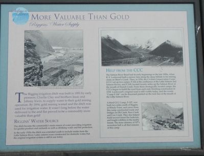
Captions: (upper left) In 1908, Riggins was known as the "garden spot of the Salmon River." Notice the main ditch humming parallel with the river. Wooden flumes carried water fro the ditch to the fields.; (top right) View of Camp F-106 in the bottom right corner in February 1939.; (bottom right) Camp F-107.
Riggins’ Water Source
The ditch became the community’s main source of water providing irrigation for garden produce and orchards as well as drinking water and fire protection.
In the early 1920s the ditch was extended south to include intake from the Little Salmon River. Later, cisterns were constructed for domestic water, but the original irrigation system is still in use today.
The Salmon River Road had its early beginnings in the late 1890s, when R.E. Lockwood built a narrow lane along the steep hillside to his mining claim on Short’s Creek. Then, in 1934, the Civilian Conservation Corps (CCC) set up two camps: F-106 at the confluence of the Little Salmon and Salmon Rivers, and F-109, located twenty miles up the Salmon River at the mouth of French Creek. From these strategically located camps, the CCCs began to build the road from each end, finishing construction in 1938. Lockwood’s original road is still visible today, and the words “Camp F-106” can be discerned painted on the rock face at the mouth of the Little Salmon River.
A third CCC Camp, F-107, was built two miles south of Riggins at Windy Point, and crews from this camp constructed roads and bridges on Elk Creek, Race Creek and Cow Creek. They also helped build several forest fire lookouts, and fought wildfires in the nearby forests. The stone chimney of 107’s recreation hall is all that remains of this camp.
Erected by City of Riggins.
Topics and series. This historical marker is listed in these topic lists: Charity & Public Work • Natural Resources • Waterways & Vessels. In addition, it is included in the Civilian Conservation Corps (CCC) series list. A significant historical year for this entry is 1891.
Location. 45° 25.056′ N, 116° 19.074′ W. Marker is in Riggins, Idaho, in Idaho County. Marker is on Main Street (U.S. 95) near Well Street, on the right when traveling north. Touch for map. Marker is at or near this postal address: 1015 Main Street, Riggins ID 83549, United States of America. Touch for directions.
Other nearby markers. At least 8 other markers are within walking distance of this marker. Area Industries (a few steps from this marker); Memorable Homes (about 700 feet away, measured in a direct line); You’ve Got Mail (approx. 0.2 miles away); Gouge-Eye Legend (approx. 0.2 miles away); The Forest Service (approx. ¼ mile away); Clay's Swinging Bridge (approx. ¼ mile away); Riggins' Early Hotels (approx. ¼ mile away); Riggins in the 1940s (approx. 0.3 miles away). Touch for a list and map of all markers in Riggins.
Credits. This page was last revised on June 27, 2018. It was originally submitted on June 27, 2018, by Barry Swackhamer of Brentwood, California. This page has been viewed 180 times since then and 35 times this year. Photos: 1, 2. submitted on June 27, 2018, by Barry Swackhamer of Brentwood, California.
