Near Spruce Pine in McDowell County, North Carolina — The American South (South Atlantic)
The Loops
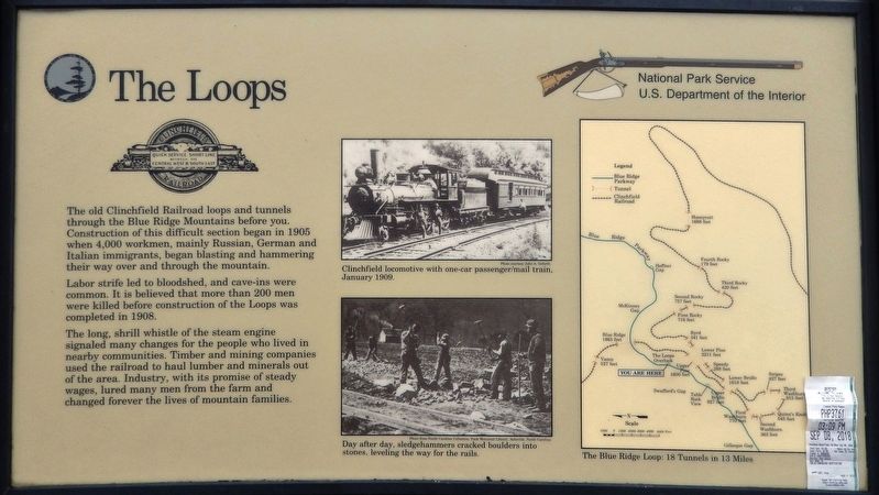
Labor strife led to bloodshed, and cave-ins were common. It is believed that more than 200 men were killed before construction of the Loops was completed in 1908.
The long, shrill whistle of the steam engine signaled many changes for the people who lived in nearby communities. Timber and mining companies used the railroad to haul lumber and minerals out of the area. Industry, with its promise of steady wages, lured many men from the farm and changed forever the lives of mountain families.
Erected by National Park Service, U.S. Department of the Interior.
Topics and series. This historical marker is listed in these topic lists: Industry & Commerce • Man-Made Features • Railroads & Streetcars. In addition, it is included in the Blue Ridge Parkway series list. A significant historical year for this entry is 1905.
Location. 35° 52.466′ N, 82° 1.544′ W. Marker is near Spruce Pine, North Carolina, in McDowell County. Marker is on Blue Ridge Parkway (at milepost 328.6), 1.2 miles south of Altapass Highway, on the left when traveling south. Marker is located at the Loops Overlook pull-out. Touch for map. Marker is in this post office area: Spruce Pine NC 28777, United States of America. Touch for directions.
Other nearby markers. At least 8 other markers are within 6 miles of this marker, measured as the crow flies. Sounds From the Mountains (a few steps from this marker); First Mountain Parkway (approx. 1.1 miles away); Gillespie Gap (approx. 2 miles away); Apple Tree (approx. 2 miles away); "The Blackwater Men Had Come Over the Mountain" (approx. 2 miles away); Spruce Pine Mining District (approx. 2 miles away); Near This Point (approx. 3.8 miles away); Cathey's Fort (approx. 5.3 miles away). Touch for a list and map of all markers in Spruce Pine.
Regarding The Loops. The railroad travels along almost 32 miles and passes through 18 tunnels as it ascends the Blue Ridge. The construction of the railway began in 1886. However, the struggle with the mountains, funding and land slowed the progress of the railway. In 1909 the rails were in place over the Blue Ridge. The Clinchfield Railroad was complete and running by 1915.
Also see . . . Clinchfield Loops. The Clinchfield Loops were an engineering marvel of their day, a series of twisting and turning horseshoe curves located south of Spruce Pine, North Carolina in the state's western Smoky Mountains which kept the grades of the Carolina, Clinchfield & Ohio Railway (better known as the Clinchfield) to a reasonable stature of under 2%. The completion of the CC&O marked decades of attempts in building a railroad from the Kentucky to South Carolina. Today, the loops and the former CC&O main line have been closed as a through route but remain under railroad ownership. Its future is unknown but trains rumbling in the hills of this part of southern Appalachia will likely not be heard throughout the foreseeable future and many never again. (Submitted on September 11, 2018, by Cosmos Mariner of Cape Canaveral, Florida.)
Credits. This page was last revised on January 1, 2023. It was originally submitted on September 11, 2018, by Cosmos Mariner of Cape Canaveral, Florida. This page has been viewed 824 times since then and 56 times this year. Photos: 1, 2. submitted on September 11, 2018, by Cosmos Mariner of Cape Canaveral, Florida. • Andrew Ruppenstein was the editor who published this page.

