Near Wisdom in Beaverhead County, Montana — The American West (Mountains)
A Story of Fires... to be continued

Photographed By Barry Swackhamer, May 12, 2018
1. A Story of Fires... to be continued Marker
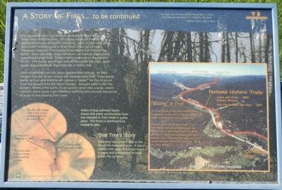
Captions: (lower left) Pollen in bog sediment layers show that plant communities have not change in Trail Creek in 4,000 years. The forest is dominated by lodgepole pine. ONE TREE'S STORY Each ring represents a year in the life of this lodgepole pine. It was a mature tree when it was cut down in 2000 and is estimated to have grown for 132 years. It was a seedling in 1868. A fire burned one side in 1885. The fire scar healed until it was just a slender crease in the tree's trunk. This blue stain is from fungus introduced by a beetle.
Two hundred years ago William Clark saw a forest of young trees, many killed by fire. Very open stands of trees were probably common along the meadows. Scars in tree rings show that minor fires occurred in Trail Creek every 30 to 40 years. These low intensity fires cleared underbrush and thinned the forest. Since the early 1900s however, we have prevented and suppressed forest fires. Today's forest matured in the absence of fire. The stands are denser and contain more old trees, dead wood, and underbrush than they did in Clark's day.
Trees established 130-200 years ago are now mature. As they weaken and die, forest insects and diseases take hold. Dead wood builds up fuel, and underbrush creates a "ladder" for fire to travel from the ground into the forest canopy. Drought adds to the fire danger. When a fire starts, it can quickly grow into a large, severe wildfire. Since 2000, high intensity wildfires have burned thousands of acres in and around Trail Creek.
(sidebar at lower right:)
"Blazing" A Trail
In Trail Creek, fires have burned more frequently in the last 1,700 years than might be expected due to lightning.
Indians used fire in many ways. Fires started by Indians probably kept the forest open, improving travel for large parties of hundreds of people and their horses. For centuries this was the main route between the Bitterroot and Big Hole valleys.
Erected by U.S. Forest Service, Bitterroot National Forest.
Topics. This historical marker is listed in these topic lists: Disasters • Horticulture & Forestry. A significant historical date for this entry is July 8, 1806.
Location. 45° 39.27′ N, 113° 46.83′ W. Marker is near Wisdom, Montana, in Beaverhead County. Marker is at the intersection of State Highway 43 and May Creek Campground Road, on the right when traveling east on State Highway 43. Touch for map. Marker is in this post office area: Wisdom MT 59761, United States of America. Touch for directions.
Other nearby markers. At least 8 other markers are within 9 miles of this marker, measured as the crow flies. Natural Travel Corridor (approx. 1.6 miles away); Big Hole National Battlefield Monument (approx. 6.2 miles away); Siege Site (approx. 6.2 miles away); Brave Warriors (approx. 6.2 miles away); A Perfect Place to Rest (approx. 6.3 miles away); Battlefield Landscape (approx. 6.7 miles away); Jerry Fahey’s Cutoff (approx. 8.2 miles away in Idaho); Lost Trail Pass (approx. 8.2 miles away in Idaho). Touch for a list and map of all markers in Wisdom.
Credits. This page was last revised on September 24, 2018. It was originally submitted on September 24, 2018, by Barry Swackhamer of Brentwood, California. This page has been viewed 221 times since then and 23 times this year. Photos: 1, 2. submitted on September 24, 2018, by Barry Swackhamer of Brentwood, California.
