Near San Juan Capistrano in Orange County, California — The American West (Pacific Coastal)
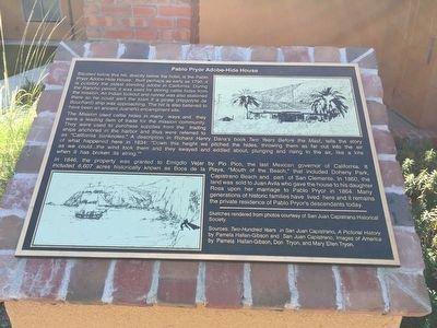
Pablo Pryor Adobe-Hide House
Inscription.
Situated below this hill, directly below the hotel, is the Pablo Pryor Adobe-Hide House. Built perhaps as early as 1790, it is possibly the oldest standing adobe in California. During the Rancho period, it was used for storing cattle hide from the mission. An Indian lookout and runner was also stationed there so he could alert the town if a pirate (Hippolyte de Bouchard) ship was approaching. The hill is also believed to have been an ancient Juaneño encampment site.
The Mission used cattle hides in many ways and they were a leading item of trade for the mission community. They were used to purchase supplies from the trading ships anchored in the harbor and thus were referred to as "California banknotes." A description in Richard Henry Dana's book Two Years Before the Mast, tells the story of what happened here in 1834: "Down this height we pitted the hides, throwing them as for out into the air as we could...the wind took them and they swayed and eddied about, plunging and rising in the air, like a kite when it has broken it's string."
In 1846, the property was granted to Emigdio Vejar by Pio Pico, the last Mexican Governor of California. It included 6,607 acres historically known as Boca de la Playa, "Mouth of the Beach," that included Doheny Park, Capistrano Beach and part of San Clemente. In 1860, the land was sold to Juan Avila who gave the house to his daughter Rosa upon her marriage to Pablo Pryor in 1864. Many generations of historic families have lived here ant it remains the private residence of Pablo Pryor's descendants today.
Topics. This historical marker is listed in these topic lists: Hispanic Americans • Notable Buildings • Settlements & Settlers. A significant historical year for this entry is 1790.
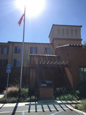
Location. 33° 28.397′ N, 117° 40.566′ W. Marker is near San Juan Capistrano, California, in Orange County. Marker can be reached from Stonehill Drive, on the right when traveling east. The marker is located near the entrance to the Residence Inn Dana Point San Juan Capistrano. Touch for map. Marker is at or near this postal address: 33711 Camino Capistrano, San Juan Capistrano CA 92675, United States of America. Touch for directions.
Other nearby markers. At least 8 other markers are within walking distance of this marker. Dana Point's Early Years (approx. ¾ mile away); California's Highway 1 (approx. ¾ mile away); The Richfield Tower (approx. ¾ mile away); Doheny State Beach (approx. ¾ mile away); The Endless Summer (approx. 0.8 miles away); Surfin' Dana Point (approx. 0.8 miles away); Bruce Brown (1937-2017) (approx. 0.8 miles away); Hobie Alter / The Surfboard King (approx. 0.8 miles away).
Also see . . .
1. The Hide House Adobe. An article written for the Capistrano Dispatch by Don Tryon tells a short history of the adobe and its residents. (Submitted on March 15, 2016.)
2. It’s History: Rancho Boca de la Playa Plants Capistrano Beach Roots. An article written for the Dana Point Times by Carlos N. Olvera. (Submitted on March 15, 2016.)
Credits. This page was last revised on February 19, 2024. It was originally submitted on March 14, 2016, by Adam Margolis of Mission Viejo, California. This page has been viewed 1,487 times since then and 130 times this year. Last updated on January 3, 2022, by Adam Margolis of Mission Viejo, California. Photos: 1, 2. submitted on March 14, 2016, by Adam Margolis of Mission Viejo, California. • J. Makali Bruton was the editor who published this page.

