Hexham in Northumberland, England, United Kingdom — Northwestern Europe (the British Isles)
16th Century Bastle House
16th Century Bastle House
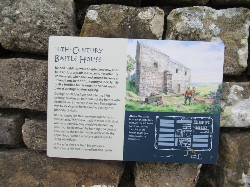
Ruined buildings were adapted and new ones built at Housesteads in the centuries after the Romans left, when the land around became an upland farm. In the 16th century a local family built a fortified house onto the ruined south gate as a refuge against raiding.
During the Middle Ages and into the 17tlh century, families on both sides of the border with Scotland were involved in raiding. The purpose was to steal cattle, horses and to destroy the property of rivals.
Bastle houses like this one were built to resist such attacks. They were made in stone with thick walls and very few, tiny windows so that they could not be destroyed by burning. The ground floor was to shelter animals in safety while the upper floor, reached only by a ladder, was for living and refuge.
In the safer times of the 18th century, a corn-drying kiln was inserted into this bastle.
( photo caption )
Above: The bastle house in the late 16th century. The left-hand part incorporated the ruins of the Roman south gate. Reconstruction by Philip Corke
Topics. This historical marker is listed in these topic lists: Forts and Castles • Settlements & Settlers.
Location. 55° 0.775′ N, 2° 19.776′ W. Marker is in Hexham, England, in Northumberland. Marker can be reached from England Route B6319, 2.9 kilometers west of North Road, on the right when traveling west. Located at Housesteads Roman Fort. Touch for map. Marker is in this post office area: Hexham, England NE47 6NW, United Kingdom. Touch for directions.
Other nearby markers. At least 8 other markers are within walking distance of this marker. The Fort and its Design (here, next to this marker); The Vicus (within shouting distance of this marker); Mediterranean Style in Northern Climes (within shouting distance of this marker); The Comanding Officer and his House (within shouting distance of this marker); The Heart of the Fort (within shouting distance of this marker); A Changing Fort (within shouting distance of this marker); Where the Soldiers Lived (about 90 meters away, measured in a direct line); Barracks: the Last Hundred Years at Housesteads (about 90 meters away). Touch for a list and map of all markers in Hexham.
Also see . . .
1. English Heritage - Housesteads Roman Fort. (Submitted on November 16, 2018, by Michael Herrick of Southbury, Connecticut.)
2. Housesteads Roman Fort on Wikipedia. (Submitted on November 16, 2018, by Michael Herrick of Southbury, Connecticut.)
Credits. This page was last revised on January 27, 2022. It was originally submitted on November 16, 2018, by Michael Herrick of Southbury, Connecticut. This page has been viewed 192 times since then and 20 times this year. Photos: 1, 2. submitted on November 16, 2018, by Michael Herrick of Southbury, Connecticut.

