Havre de Grace in Harford County, Maryland — The American Northeast (Mid-Atlantic)
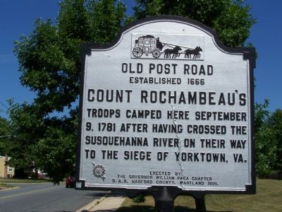
Count Rochambeauís Troops
Old Post Road
ó Established 1666 ó
Erected 1931 by the Governor William Paca Chapter D.A.R. Harford County, Maryland.
Topics and series. This historical marker is listed in these topic lists: Roads & Vehicles • War, US Revolutionary • Waterways & Vessels. In addition, it is included in the Daughters of the American Revolution, and the The Washington-Rochambeau Route series lists. A significant historical month for this entry is September 1945.
Location. 39° 32.55′ N, 76° 6.089′ W. Marker is in Havre de Grace, Maryland, in Harford County. Marker is on Lewis Lane, 0.1 miles Old Post Road (Maryland Route 7), on the right when traveling north. Touch for map. Marker is in this post office area: Havre de Grace MD 21078, United States of America. Touch for directions.
Other nearby markers. At least 8 other markers are within walking distance of this marker. Home of Refuge (approx. 0.2 miles away); Havre de Grace Colored High School (approx. 0.4 miles away); Dedicated in Honor (approx. half a mile away); No Respect (approx. 0.6 miles away); Ernest Burke (approx. 0.7 miles away); Votes for Women (approx. 0.7 miles away); Havre de Grace Racetrack (approx. 0.7 miles away); Havre de Grace War Memorial (approx. 0.7 miles away). Touch for a list and map of all markers in Havre de Grace.
Credits. This page was last revised on March 21, 2020. It was originally submitted on June 24, 2007, by Bill Pfingsten of Bel Air, Maryland. This page has been viewed 2,118 times since then and 17 times this year. Last updated on March 20, 2020, by Carl Gordon Moore Jr. of North East, Maryland. Photo 1. submitted on June 24, 2007, by Bill Pfingsten of Bel Air, Maryland.
