National Harbor in Fort Washington in Prince George's County, Maryland — The American Northeast (Mid-Atlantic)
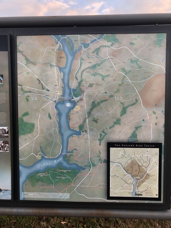
Discover Gorgeous Southern Prince George's

Photographed By Devry Becker Jones (CC0), December 22, 2018
1. Discover Gorgeous Southern Prince George's Marker
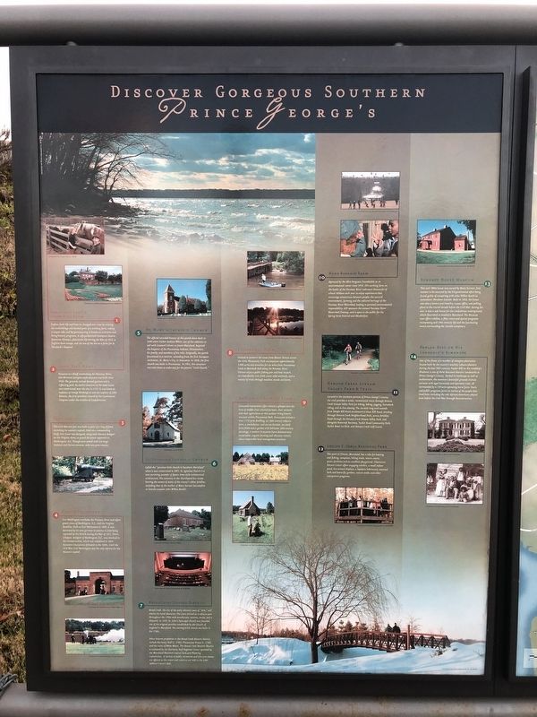
1. Oxon Cove Farm & Oxon Hill Farm
Explore farm life and how it's changed over time by visiting the outbuildings and animal pens of a working farm, taking a wagon ride, and by participating in hands-on activities and living history programs. A self-guided trail interprets Native American lifeways, plantation life during the War of 1812, a fugitive slave escape, and the use of a site as a farm for St. Elizabeth's Hospital.
2. Oxon Hill Manor
Situated on a bluff overlooking the Potomac River, this 49-room Georgian-style mansion was built circa 1928. The grounds include formal gardens and a reflecting pool. An earlier mansion of the same name was constructed near the site in 1710. It was home to nephews of George Washington and the nephew of John Hanson, the first president elected by the Continental Congress under the Articles of Confederation.
3. Fort Foote
This Civil War-era fort was built as part of a ring of forts enclosing the nation's capital. Sited on a commanding bluff, Fort Foote was designed, along with Battery Rodgers on the Virginia shore, to guard the water approach to Washington, D.C. Though once armed with ten large Rodman and Parrot cannons, only two guns remain.
4. Fort Washington
Fort Washington overlooks the Potomac River and offers grand views of Washington, D.C., and the Virginia shoreline. Built as Fort Warburton in 1809, it was destroyed by its own garrison to prevent it from being captured by the British during the War of 1812. Pierre L'Enfant, designer of Washington, D.C., was involved in the reconstruction, which was completed in 1824. Extensive renovations followed in the 1840s. Until the Civil War, Fort Washington was the only defense for the Nation's Capital.
5. St. Mary's Catholic Church
The official recorded history of this parish dates back to 1640 when Father Andrew White, one of the colonists to sail with Leonard Calvert to found Maryland, baptized the Emperor of the Piscataway Indians, Chitomachen, his family, and members of his tribe. Originally, the parish functioned as a mission, extending from the first European settlement, St. Mary's City, to Anacostia. In 1838 the first church was built in Piscataway. In 1901, this structure was torn down to make way for the present "Little Church."
6. St. Ignatius Catholic Church
Called the "prettiest little church in Southern Maryland" when it was consecrated in 1891, St. Ignatius Church is a rare surviving example of Queen Anne style ecclesiastical architecture. The cemetery in the churchyard has stones bearing the names of many of the country's oldest families, including that of the mother of Mary Surratt

Photographed By Devry Becker Jones (CC0), December 22, 2018
2. Discover Gorgeous Southern Prince George's Marker
7. Broad Creek Historic District
Broad Creek, the site of the early colonial town of "Aire," still retains its rural character. The town thrived as a tobacco port throughout the 1700s with warehouses, taverns, stores, and a shipyard. In 1692, St. John's Episcopal Church was founded, one of the original parishes established by the Church of England in Maryland. The existing brick church was built in the 1760s.
Other historic properties in the Broad Creek Historic District include Harmony Hall (c. 1760), Piscataway House (c. 1750), and the ruins of Want Water. The Broad Creek Historic District is anchored by Harmony Hall Regional Center operated by the Maryland-National Capital Park and Planning Commission. A variety of public recreation and fine arts classes are offered at the center and concerts are held in the John Addison Concert Hall.
8. Piscataway Park
Created to preserve the views from Mount Vernon across the river, Piscataway Park encompasses approximately 5,000 acres and stretches for six miles from Piscataway Creek to Marshall Hall along the Potomac River. Visitors enjoy a public fishing pier and boat launch, two boardwalks over fresh water tidal wetlands, and a variety of trails through meadow, woods and farm.
9. National Colonial Farm
Costumed

Photographed By Devry Becker Jones (CC0), December 22, 2018
3. Discover Gorgeous Southern Prince George's Marker
10. Hard Bargain Farm
Operated by the Alice Ferguson Foundation as an environmental center since 1954, this working farm on the banks of the Potomac River welcomes thousands of school children each year to enjoy experience that encourage connections between people, the natural environment, farming and the cultural heritage of the Potomac River Watershed, leading to personal environmental responsibility. AFF sponsors the annual Potomac River Watershed Cleanup, and is open to the public for the Spring Farm Festival and Oktoberfest.
11. Henson Creek Stream Valley Park & Trail
Located in the southern portion of Prince George's County, the trail provides a scenic, recreational route through Henson Creek Stream Valley Park for hiking, biking, jogging, horseback riding, and in-line skating. The six-mile long trail extends from Temple Hill Road southward to Oxon Hill Rod, winding through Henson Creek Neighborhood Park, across Brinkley Road through the Henson Creek Stream Valley Park, and alongside Rosecroft Raceway, Tucker Roof Community Park, Tucker Road Ice Rink, and Henson Creek Golf Course.
12. Louise F. Corca Regional Park
This park in Clinton, Maryland has a lake for boating and fishing, campsites, hiking trails, tennis courts, picnic facilities and an excellent playground. Clearwater Nature Center offer engaging exhibits, a small indoor pond, live animal displays, a lapidary laboratory, seasonal herb and butterfly gardens, nature walks and other interpretive programs.
13. Surratt's House Museum
This mid-1800s house was owned by Mary Surratt, first woman to be executed by the US government for being found guilty of conspiring with John Wilkes Booth to assassinate Abraham Lincoln. Built in 1852,the house was also a tavern and hostelry, a post office, and polling place in the crucial decade before the Civil War. During the war, it was a safe house for the Confederate underground, which flourished in Southern Maryland. The Museum now offers exhibits, a film, tours and special programs interpreting mid-19th century life and the fascinating events surrounding the Lincoln conspiracy.
14. Poplar Hill on His Lordship's Kindness
One of the finest of a number of Georgian plantation houses built by the country's wealthy tobacco planters during the late 18th century, Poplar Hill on His Lordship's Kindness is one of three National Historic Landmarks in Prince George's County. Formal in landscape as well as architecture, the mansion's beautiful grounds include terraces with aged boxwoods and specimen trees, all surrounded by a 130-acre operated horse farm. Tours and public programs focus on stories of the people that lived here, including the role African-Americans played from before the Civil War through Reconstruction.
Topics and series. This historical marker is listed in these topic lists: African Americans • Churches & Religion • War, US Civil • Women. In addition, it is included in the Booth's Escape series list. A significant historical year for this entry is 1812.
Location. 38° 47.49′ N, 77° 0.951′ W. Marker is in Fort Washington, Maryland, in Prince George's County. It is in the National Harbor. Marker is at the intersection of National Harbor Boulevard and Capital Beltway (Interstate 95), on the right when traveling south on National Harbor Boulevard. This marker is along the walking trail between National Harbor and the Woodrow Wilson Bridge. Touch for map. Marker is in this post office area: Oxon Hill MD 20745, United States of America. Touch for directions.
Other nearby markers. At least 8 other markers are within walking distance of this marker. Archaeology at Oxon Hill (about 600 feet away, measured in a direct line); After the Addisons (approx. 0.2 miles away); The Architecture of Oxon Hill Manor (approx. 0.2 miles away); Africans Becoming Americans (approx. ¼ mile away); The First People (approx. ¼ mile away); Franklin D. Roosevelt (approx. 0.3 miles away); Dwight D. Eisenhower (approx. 0.3 miles away); Shifting Sands: The Story of Rosalie Island (approx. 0.3 miles away).
More about this marker. On item 1: The official spelling is St. Elizabeths Hospital.
Also see . . . Booth's Escape Byway, Maryland Office of Tourism. (Submitted on August 19, 2019.)
Credits. This page was last revised on September 6, 2023. It was originally submitted on December 23, 2018, by Devry Becker Jones of Washington, District of Columbia. This page has been viewed 245 times since then and 18 times this year. Last updated on July 21, 2022, by Carl Gordon Moore Jr. of North East, Maryland. Photos: 1, 2, 3. submitted on December 23, 2018, by Devry Becker Jones of Washington, District of Columbia. • J. Makali Bruton was the editor who published this page.