Near Darlington in Harford County, Maryland — The American Northeast (Mid-Atlantic)
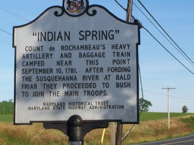
“Indian Spring”
Erected by Maryland Historical Trust, Maryland State Highway Administration.
Topics and series. This historical marker is listed in these topic lists: War, US Revolutionary • Waterways & Vessels. In addition, it is included in the Maryland Historical Trust, and the The Washington-Rochambeau Route series lists. A significant historical date for this entry is September 10, 1923.
Location. 39° 36.625′ N, 76° 15.613′ W. Marker is near Darlington, Maryland, in Harford County. Marker is on Priestford Road (Route 136) south of Trappe Road, on the left when traveling north. Touch for map. Marker is in this post office area: Darlington MD 21034, United States of America. Touch for directions.
Other nearby markers. At least 8 other markers are within 4 miles of this marker, measured as the crow flies. Capt. Angus Greme (approx. half a mile away); Joesting - Gorsuch House (approx. 1.8 miles away); Deer Creek Harmony Presbyterian Church (approx. 3.2 miles away); Church of the Holy Trinity (approx. 3˝ miles away); Churchville Presbyterian Church (approx. 3.6 miles away); Churchville (approx. 3.6 miles away); Springhouse (approx. 3.7 miles away); a different marker also named Springhouse (approx. 3.7 miles away).
Credits. This page was last revised on March 21, 2020. It was originally submitted on June 24, 2007, by Bill Pfingsten of Bel Air, Maryland. This page has been viewed 5,174 times since then and 132 times this year. Photos: 1. submitted on June 24, 2007, by Bill Pfingsten of Bel Air, Maryland. 2, 3. submitted on July 4, 2007, by Bill Pfingsten of Bel Air, Maryland. • J. J. Prats was the editor who published this page.


