Soda Springs in Placer County, California — The American West (Pacific Coastal)
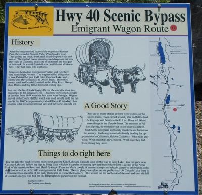
Emigrant Wagon Route
Hwy 40 Scenic Bypass
After the emigrants had successfully negotiated Donner Pass, they rested in Summit Valley (Van Norden now). They grazed the stock, drank their fill of the pure water and rested. The trip had been exhausting and dangerous but now they were in California and ready to undertake the final part of their trek. It was all downhill now (well almost all downhill). They had made it to California.
Emigrants headed up from Summit Valley and right here they turned right, or west. The wagons rolled along what is now Pahatsi Rd. past Kidd Lake, Cascade Lake, and others until they got almost to Devil's Peak. There they turned north and headed downhill to the Yuba River, Hampshire Rocks, and Big Bend, their next resting spot.
Just over the lip of Soda Springs Rd. on the east side there is a monument to the Emigrant Trail. This route only lasted a couple of decades from 1844 when the first train went through. Wagons moved to the Dutch Flat Rd. which was used to help build the railroad in the 1860's (approximately what Hiway 40 is today). Just imagine what this emigrant road saw and the stories it could tell.
A Good Story
There are as many stories as there were wagons on the wagon trains. Each carried a family that had left behind belongings and family in the U.S.A. Many left behind more things in the Nevada desert. The museum in Fallon, Nevada is worth the visit to see what was left behind. Each wagon carried a family heading for opportunities in California, Golden California. What risks they took. What hardships they endured. What hope they had. How strong they were.
Things to do right here
You can take this road for some miles west, passing Kidd Lake and Cascade Lake all the way to Long Lake. You can park near Cascade Lake and follow the sign to Long Lake which is a popular swimming spot and from where there is access to the North Fork of the American River and Heath Springs. There are also a couple of summer camps and school camps on the other lakes in this direction as well as a P.G.&E. campground at Kidd Lake. There is plenty to explore on the public road. At Cascade Lake there is a monument to a member of the party that came to rescue the Donners. Hike around on the north side of the road and over the hill at Cascade and you will find the old telegraph line paralleling the railroad.
Erected by Donner Summit Historical Society. (Marker Number 12.)
Topics and series. This historical marker is listed in this topic list: Roads & Vehicles. In addition, it is included in the Donner Summit Historical Society series list.
Location. 39° 18.773′ N, 120° 22.874′ W. Marker is in Soda Springs, California, in Placer County. Marker is on Soda Springs Road near Pahatsi Road, on the left when traveling south. Touch for map. Marker is at or near this postal address: 7151 Soda Springs Road, Soda Springs CA 95728, United States of America. Touch for directions.
Other nearby markers. At least 8 other markers are within 2 miles of this marker, measured as the crow flies. Truckee Trail - Leaving Summit Valley (a few steps from this marker); Lake Van Norden Dam (approx. 0.6 miles away); Soda Springs Hotel (approx. ¾ mile away); Soda Springs Store (approx. 0.8 miles away); Summit Valley Native American Mortars (approx. 0.9 miles away); Donner Summit Lodge (approx. one mile away); Central Sierra Snow Lab (approx. one mile away); Dutch Flat Donner Lake Wagon Road (approx. 1.1 miles away). Touch for a list and map of all markers in Soda Springs.
Credits. This page was last revised on June 22, 2021. It was originally submitted on February 5, 2019, by Barry Swackhamer of Brentwood, California. This page has been viewed 277 times since then and 17 times this year. Last updated on June 21, 2021, by Alvis Hendley of San Francisco, California. Photos: 1, 2. submitted on February 5, 2019, by Barry Swackhamer of Brentwood, California. • Bill Pfingsten was the editor who published this page.

