Columbia Heights in Northwest Washington in Washington, District of Columbia — The American Northeast (Mid-Atlantic)
On the Heights
Cultural Convergence
— Columbia Heights Heritage Trail —
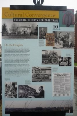
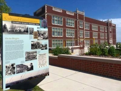
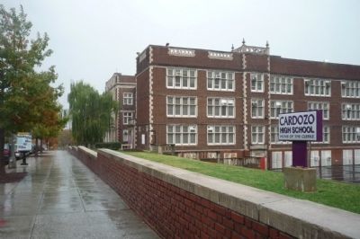
In the days of legally segregated public education (1862-1954), this school building was Central High, the gem of the School Board’s white division. But by 1949, it had few students, as the post-World War II suburban housing boom had drawn whites away. Consequently, African American families outnumbered whites around Central.
Nearby “Colored” high schools — especially Cardozo at Ninth Street and Rhode Island Avenue — struggled with overcrowded, outdated facilities. When activists pressed the city to move Cardozo’s black students to Central, the white community resisted. But the School Board could not justify the waste of space. So in September 1950, with white students relocated to other schools, Central became Cardozo, the business high school for black students. Four years later with Brown v. Board of Education, the Supreme Court nominally integrated all DC schools.
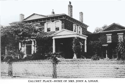
Long before there was a school here, though, this fabulous view was enjoyed by a sculptor and engraver named William J. Stone. In 1835 Stone moved into the Federal style “Mount Pleasant” house, once the center-piece of the prominent Peter family’s thousand-acre estate here. During the Civil War, the house served as a hospital. In 1881 Senator John Sherman bought 121 acres, then laid out a subdivision between 11th and 14th Streets, naming it Columbia Heights. His contemporary, Senator John A. Logan of Illinois, a Civil War general, co-founder of Memorial Day, and future vice presidential candidate (1884), bought the old mansion and renamed it Calumet Place. Later, Logan’s widow Mary rented it to Secretary of State William Jennings Bryan.
Erected 2009 by Cultural Tourism DC. (Marker Number 10.)
Topics and series. This historical marker is listed in these topic lists: African Americans • Civil Rights • Education • Settlements & Settlers. In addition, it is included in the Columbia Heights Heritage Trail series list. A significant historical month for this entry is September 1950.
Location. 38° 55.343′ N, 77° 1.763′ W. Marker is in Northwest Washington in Washington, District of Columbia. It is in Columbia Heights. Marker is on Clifton Street Northwest east of 13th Street Northwest. Touch for map. Marker is in this post office area: Washington DC 20009, United States of America. Touch for directions.
Other nearby markers. At least 8 other markers are within walking distance of this marker. Francis L. Cardozo High School (within shouting distance of this marker); Views of Justice (about 300 feet away, measured in a direct line); Justice vs. Injustice (about 500 feet away); 1968 (about 700 feet away); Mix of Cultures (approx. 0.2 miles away); Drum and Spear Bookstore Site
(approx. ¼ mile away); The Burton W. Johnson House (approx. ¼ mile away); A Place to Grow (approx. ¼ mile away). Touch for a list and map of all markers in Northwest Washington.
More about this marker. [Caption, photo in upper left:]
William J. Stone, right, posed in front of “Mount Pleasant,” which once occupied this hilltop. (Historical Society of Society of Washington, DC.)
[Caption, photos in upper right:]
Ohio Senator John Sherman, above, developer of Columbia Heights, Illinois Senator John Logan, far right, seen with wife Mary and children, and presidential candidate William Jennings Bryan, right, were two of the powerful men who occupied “Mount Pleasant.” (Library of Congress.)
[Caption, photos in center right:]
White Central High School students of the 1920s learned auto mechanics, left and bookkeeping, below. (Charles Sumner School Museum and Archives.)
[Caption, photos in lower right:]
Left, in 1940 overcrowding forced Cardozo students to meet in the basement. Citizen activists ran this full page ad, below, in the Washington Post in
December 1949. (Washington Post.)
[Caption, photo in lower right:]
Cardozo students Jerome Earbe and Barbara Henderson learn data processing from teacher Margaret G. Saxon, 1968. (Star Collection, DC Public Library © Washington Post .)
[Caption, photo in upper center:]
On March 12, 1967, the Reverend Dr. Martin Luther King, Jr. spoke here at Cardozo to a public meeting on urban renewal plans for the Shaw neighborhood. ( Star Collection, DC Public Library © Washington Post .)
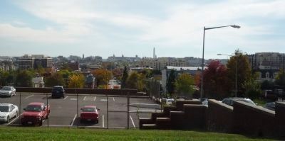
[The bottom of the marker features a photograph of downtown DC's skyline from Clifton Street near Cardozo High School. It is a 2008 photo montage, by Malini Dominey.]
Also see . . . Wikipedia entry for Francis Lewis Cardozo. (Submitted on October 25, 2009, by Richard E. Miller of Oxon Hill, Maryland.)
Additional keywords. Martin Luther King; Charles Brooks; Francis Lewis Cardozo.
Credits. This page was last revised on January 30, 2023. It was originally submitted on October 24, 2009, by Richard E. Miller of Oxon Hill, Maryland. This page has been viewed 1,909 times since then and 17 times this year. Last updated on March 7, 2019, by Devry Becker Jones of Washington, District of Columbia. Photos: 1. submitted on October 24, 2009, by Richard E. Miller of Oxon Hill, Maryland. 2. submitted on July 22, 2015, by Allen C. Browne of Silver Spring, Maryland. 3, 4. submitted on October 24, 2009, by Richard E. Miller of Oxon Hill, Maryland. 5, 6. submitted on July 22, 2015, by Allen C. Browne of Silver Spring, Maryland. • Bill Pfingsten was the editor who published this page.
Editor’s want-list for this marker. A photo of the marker reverse. • Can you help?
