Sturgeon Bay in Door County, Wisconsin — The American Midwest (Great Lakes)
Sturgeon Bay's Waterfront History
Sawyer Dock and Park
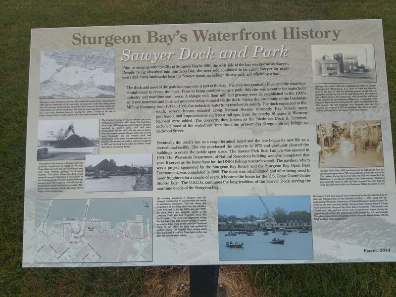
The dock and most of the parkland was once a part of the bay. The area was gradually filled and the shoreline straightened to create the dock. Prior to being established as a park, this site was a center for waterfront industry and maritime commerce. A shingle mill, flour mill and granary were all established in the 1800's with raw materials and finished products being shipped via the dock. Under the ownership of the Bushman Milling Company from 1917 to 1966, the industrial waterfront reached its zenith. The dock expanded to the south, several homes situated along Neenah Avenue (formerly Bay Street) were purchased, and improvements such as a rail spur from the nearby Ahnapee & Western Railroad were added. The property, then known as the Bushman Dock & Terminal, included most of the waterfront area from the present day Oregon Street Bridge to Redwood Street.
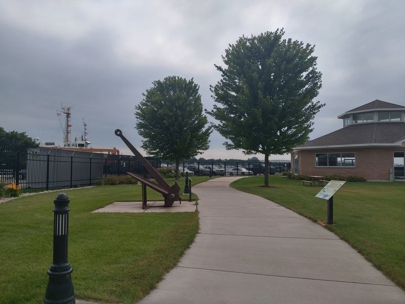
Eventually the dock's use as a cargo terminal faded and the site began its new life as a recreational facility. The city purchased the property in 1975 and gradually cleared the buildings to create the public open space. The Sawyer Park Boat Launch was opened in 1991. The Wisconsin Department of Natural Resources building was also completed that year. It serves as the home base for the DNR's fishing research vessel. The pavilion, which was a project sponsored by the Sturgeon Bay Rotary and the Sturgeon Bay Open Bass Tournament, was completed in 2006. The dock was rehabilitated and after being used to moor freighters for a couple of years, it became the home for the U.S. Coast Guard Cutter Mobile Bay. The U.S.C.G. continues the long tradition of the Sawyer Dock serving the maritime needs of the Sturgeon Bay.
Captions (counter clockwise):
The Sawyer side of Sturgeon Bay was still a relatively small cluster of buildings in 1893. But the beginning of the waterfront development is already taking shape with the Lawrence Dock and Bay View Roller Mill shown in the lower center part of this "bird's eye" artist's rendering. The dock was developed by A. W. Lawrence, one of the city's business pioneers, during the 1880's. Located at the site of today's Sawyer Park, it is the forerunner of the modern Sawyer Dock.
The freighter George F. Rand unloads coal at the Bushman Dock in this 1950's photo. The dock dates back to the 1800's and was an international shipping terminal for lumber, grain, coal and other commodities. By the 1970's the site was no longer used as a cargo terminal though ships still moored here. Eventually, the old wooden dock wall deteriorated to the point that even docking was not feasible. The modern steel sheet wall was completed in 2005 and the dock (now called the Sawyer Dock) was reborn as mooring facility.
The modern dock known as Sawyer Dock was gradually lengthened by filling in the bay. Depending upon the era, the fill material may have been sawdust, garbage, or dredged material. This photo shows the dock being extended around 1940 when it was known as the Bushman Dock. Dredged material is being pumped from the shipping channel into the area behind a newly established shoreline. The photo looks northerly with the Michigan Street Bridge in the background.
This working waterfront of Sturgeon Bay has changed considerably to accommodate the needs of waterborne commerce. This map shows this progression of the filling of the bay and extension of the dock wall. In the late 1800's and early 1900's the dock, which was originally known as the Lawrence Dock and then Washburn Dock, was much smaller. The dock was lengthened during the first half of the 20th century during its heyday as a cargo depot when it was called the Bushman Dock. By the 1960's the dock had reached its modern extent. The original street names which were used until World War II are listed on the map after the current street names.
The Sawyer Park Boat Launch was constructed by the city with the help of state and federal grants. It was dedicated on May 11, 1991, along with the neighboring Wisconsin Department of Natural Resources service center. To celebrate the new launching facility, Sturgeon Bay residents Gary & Cheryl Nault initiated the Sturgeon Bay Open Bass Tournament. This annual event is held each May and has grown from 24 two-person teams during the original event to over 400 participants from around the U.S. and Canada. This photo shows teams preparing to depart from the launch ramp, with the DNR building in the background.
The Bay View Roller Mill was known for its high grade flour and custom grain processing. This photo dates to around the turn of the 20th century during the period when the mill was owned by L.M. Washburn, a prominent Sturgeon Bay businessman. Washburn purchased the dock in 1895 and later acquired the mill. Both dock and mill were sold to the Bushman Milling Company in 1917.
The Bay View Roller Mill was established in 1885 by Charles Whiteside, L.C. Thorkildson, & A. Shaw on what was then the shore of the bay. In 1899 the adjoining granary on the left was brought to this site by water from Little Sturgeon in the southern part of Door County. The picture (ca. 1920) shows the mill when it was operated by the Bushman Milling Co. A mainstay of the Sturgeon Bay waterfront during the late 1800's and first half of the 20th century, the mill buildings were removed after the city acquired the property in 1975 for parkland. They stood in what is now the parking lot for the Sawyer Park Boat Launch.
Erected 2014.
Topics. This historical marker is listed in these topic lists: Industry & Commerce • Waterways & Vessels.
Location. 44° 49.731′ N, 87° 22.879′ W. Marker is in Sturgeon Bay, Wisconsin, in Door County. Marker can be reached from South Neenah Avenue. Touch for map. Marker is at or near this postal address: Sawyer Park, S Neenah Ave, Sturgeon Bay WI 54235, United States of America. Touch for directions.
Other nearby markers. At least 8 other markers are within walking distance of this marker. The Fluke Anchor (here, next to this marker); a different marker also named Sturgeon Bay's Waterfront History (within shouting distance of this marker); Ship Propellers (within shouting distance of this marker); a different marker also named Sturgeon Bay's Waterfront History (within shouting distance of this marker); a different marker also named Sturgeon Bay's Waterfront History (within shouting distance of this marker); a different marker also named Sturgeon Bay's Waterfront History (within shouting distance of this marker); Buoy and Sinker (within shouting distance of this marker); a different marker also named Sturgeon Bay's Waterfront History (about 300 feet away, measured in a direct line). Touch for a list and map of all markers in Sturgeon Bay.
Credits. This page was last revised on February 28, 2020. It was originally submitted on March 26, 2019, by Devon Polzar of Port Washington, Wisconsin. This page has been viewed 345 times since then and 65 times this year. Last updated on February 28, 2020, by Devon Polzar of Port Washington, Wisconsin. Photos: 1, 2. submitted on March 26, 2019, by Devon Polzar of Port Washington, Wisconsin. • Mark Hilton was the editor who published this page.

