Near Germantown in Montgomery County, Maryland — The American Northeast (Mid-Atlantic)
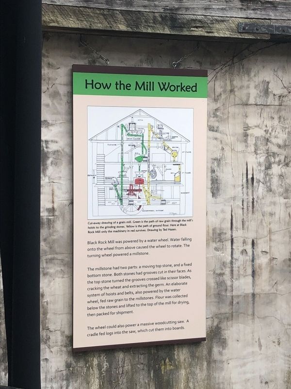
How the Mill Worked
The millstone had two parts: a moving top stone, and a fixed bottom stone. Both stones had grooves cut in their faces. As the top stone turned the grooves crossed like scissor blades, cracking the wheat and extracting the germ. An elaborate system of hoists and belts, also powered by the water wheel, fed raw grain to the millstones. Flour was collected below the stones and lifted to the top of the mill for drying, then packed for shipment.
The wheel could also power a massive woodcutting saw. A cradle fed logs into the saw, which cut them into boards.
Erected by Maryland Park Service.
Topics. This historical marker is listed in this topic list: Industry & Commerce. A significant historical year for this entry is 1811.
Location. 39° 7.631′ N, 77° 18.877′ W. Marker is near Germantown, Maryland, in Montgomery County. Marker can be reached from Black Rock Road north of Grey Pebble Way, on the left when traveling north. Touch for map. Marker is at or near this postal address: 16500 Black Rock Road, Germantown MD 20874, United States of America. Touch for directions.
Other nearby markers. At least 8 other markers are within 2 miles of this marker, measured as the crow flies. A Mixed Community (here, next to this marker); Black Rock Mill and Great Seneca Creek (within shouting distance of this marker); White’s Ferry (approx. 1½ miles away); The Cliff Bland Recreation Area (approx. 1.7 miles away); Darnestown (approx. 1.8 miles away); The Signal Corps and Wartime Communications (approx. 2.1 miles away); The Civil War in Darnestown (approx. 2.1 miles away); Civil War Troops & Darnestown Residents (approx. 2.1 miles away). Touch for a list and map of all markers in Germantown.
Credits. This page was last revised on March 31, 2019. It was originally submitted on March 30, 2019, by Devry Becker Jones of Washington, District of Columbia. This page has been viewed 156 times since then and 3 times this year. Photos: 1, 2. submitted on March 30, 2019, by Devry Becker Jones of Washington, District of Columbia.

