Washington Township near Waynesboro in Franklin County, Pennsylvania — The American Northeast (Mid-Atlantic)
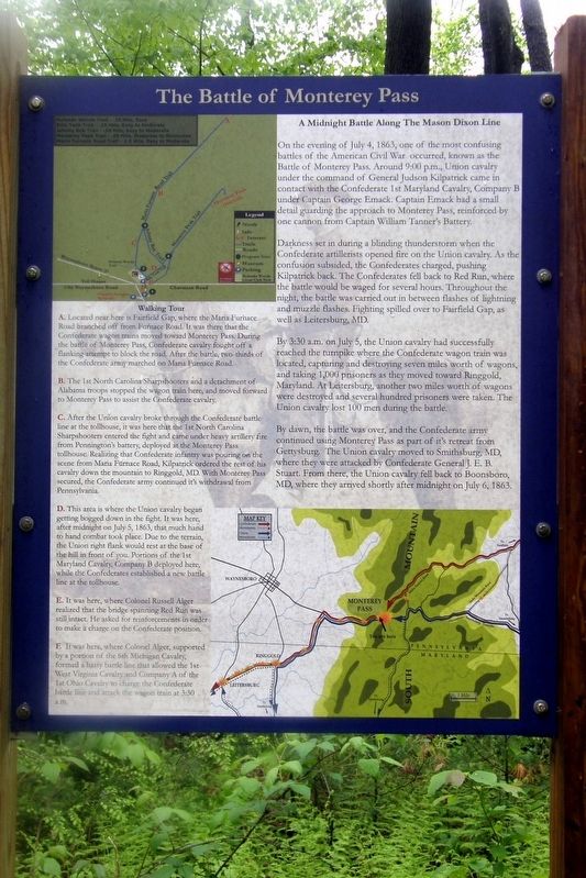
The Battle of Monterey Pass
A Midnight Battle Along The Mason-Dixon Line
On the evening of July 4, 1863, one of the most confusing battles of the American Civil War occurred, known as the Battle of Monterey Pass. Around 9:00 p.m., Union cavalry under the command of General Judson Kilpatrick came in contact with the Confederate 1st Maryland Cavalry, Company B under Captain George Emack. Captain Emack had a small detail guarding the approach to Monterey Pass, reinforced by one cannon from Captain William Tannerís Battery.
Darkness set in during a blinding thunderstorm when the Confederate artillerists opened fire on the Union cavalry. As the confusion subsided, the Confederates charged, pushing Kilpatrick back. The Confederates fell back to Red Run, where the battle would be waged for several hours. Throughout the night, the battle was carried out in between flashes of lightning and muzzle flashes. Fighting spilled over to Fairfield Gap, as well as Leitersburg, MD.
By 3:30 a.m. on July 5, the Union cavalry had successfully reached the turnpike where the Confederate wagon train was located, capturing and destroying seven miles worth of wagons, and taking 1,000 prisoners as they moved toward Ringgold, Maryland. At Leitersburg, another two miles worth of wagons were destroyed and several hundred prisoners were taken. The Union cavalry lost 100 men during the battle.
By dawn, the battle was over, and the Confederate army continued using Monterey Pass as part of itís (sic) retreat from Gettysburg. The Union cavalry moved to Smithsburg, MD, where they were attacked by Confederate General J.E.B. Stuart. From there, the Union cavalry fell back to Boonsboro, MD, where they arrived shortly after midnight on July 6, 1863.
Walking Tour
A. Located near here is Fairfield Gap, where the Maria Furnace Road branched off from Furnace Road. It was there that the Confederate wagon trains moved toward Monterey Pass. During the Battle of Monterey Pass Confederate cavalry fought off a flanking attempting to block the road. After the battle, two-thirds of the Confederate army marched on Maria Furnace Road.
B. The 1st North Carolina Sharpshooters and a detachment of Alabama troops stopped the wagon train here, and moved forward to Monterey Pass to assist the Confederate cavalry.
C. After the Union cavalry broke through the Confederate battle line at the tollhouse, it was here that the 1st North Carolina Sharpshooters entered the fight and came under heavy artillery fire from Penningtonís battery, deployed at the Monterey Pass tollhouse. Realizing that Confederate infantry was pouring on the scene from Maria Furnace Road, Kilpatrick ordered the rest of the cavalry down
the mountain to Ringgold, MD. With Monterey Pass secured, the Confederate army continued itís (sic) withdrawal from Pennsylvania.
D. This area is where the Union cavalry began getting bogged down in the fight. It was here, after midnight on July 5, 1863, that much hand to hand combat took place. Due to the terrain, the Union right flank would rest at the base of the hill in front of you. Portions of the 1st Maryland Cavalry, Company B deployed here, while the Confederates established a new battle line at the toll house.
E. It was here, where Colonel Russell Alger realized that the bridge spanning Red Run was still intact. He asked for reinforcements in order to make a charge on the Confederate position.
F. It was here, where Colonel Alger, supported by a portion of the 6th Michigan Cavalry, formed a hasty battle line that allowed the 1st West Virginia Cavalry and Company A of the 1st Ohio Cavalry to charge the Confederate battle line and attack the wagon train at 3:30 a.m.
Topics. This historical marker is listed in this topic list: War, US Civil. A significant historical date for this entry is July 4, 1863.
Location. 39° 44.345′ N, 77° 28.763′ W. Marker is near Waynesboro, Pennsylvania, in Franklin County. It is in Washington Township. Marker can be reached from Charmian Road near Buchanan Trail East/Waynesboro Road, on the right when traveling west. Touch for map. Marker is at or near this postal address: 9 Charmian Rd, Waynesboro PA 17268, United States of America. Touch for directions.
Other nearby markers. At least 8 other markers are within walking distance of this marker. The Underground Railroad (here, next to this marker); The Raid On Harpers Ferry (here, next to this marker); Before The Battle Of Gettysburg (a few steps from this marker); Blue Ridge Summit Lions (within shouting distance of this marker); The Retreat From Gettysburg (within shouting distance of this marker); Brown's Spring (within shouting distance of this marker); a different marker also named The Battle of Monterey Pass (within shouting distance of this marker); a different marker also named The Battle of Monterey Pass (about 300 feet away, measured in a direct line). Touch for a list and map of all markers in Waynesboro.
Also see . . . Fight at Monterey Pass. Wikipedia entry. (Submitted on April 17, 2020, by Larry Gertner of New York, New York.)
Credits. This page was last revised on February 7, 2023. It was originally submitted on July 1, 2019, by Larry Gertner of New York, New York. This page has been viewed 358 times since then and 21 times this year. Last updated on July 11, 2022, by Carl Gordon Moore Jr. of North East, Maryland. Photos: 1, 2, 3. submitted on July 1, 2019, by Larry Gertner of New York, New York. • Bernard Fisher was the editor who published this page.


