Near Calhoun in Gordon County, Georgia — The American South (South Atlantic)
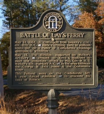
Battle of Lay's Ferry
May 14, 1864. A contingent from Sweeny's (2d) div., 16th A.C. [US] made a crossing here in pontoon boats, but on a rumor of Confederate crossings upstream, it withdrew.
May 15. The division, supported by Welker's Artillery [US], crossed in force & deployed to meet the immediate attack by Maj. Gen. W.H.T. Walker's div., Hardee's A.C. [CS], in the area between the George W. Frix house & the Oostanaula River.
This Federal move on the Confederate left & rear forced Johnston [CS] to evacuate his lines at Resaca.
Erected 1953 by Georgia Historical Commission. (Marker Number 064-19.)
Topics and series. This historical marker is listed in this topic list: War, US Civil. In addition, it is included in the Georgia Historical Society series list. A significant historical date for this entry is May 14, 1836.
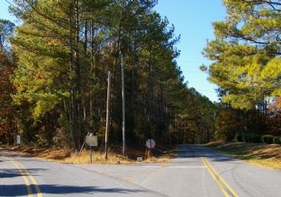
Location. 34° 31.005′ N, 84° 59.418′ W. Marker is near Calhoun, Georgia, in Gordon County. Marker is at the intersection of Herrington Bend Road and Hunt Road, on the left when traveling north on Herrington Bend Road. Touch for map. Marker is in this post office area: Calhoun GA 30703, United States of America. Touch for directions.
Other nearby markers. At least 8 other markers are within 4 miles of this marker, measured as the crow flies. Lay’s Ferry (approx. 1½ miles away); Johnston's Rear Guard Stops McPherson (approx. 2.1 miles away); Roland Hayes (approx. 2.2 miles away); Calhoun Depot (approx. 2.3 miles away); a different marker also named The Calhoun Depot (approx. 2.3 miles away); Calhoun, Ga, May 18, 1864. (approx. 2.4 miles away); Gordon County (approx. 2.4 miles away); Calhoun War Memorial (approx. 3.2 miles away). Touch for a list and map of all markers in Calhoun.
Regarding Battle of Lay's Ferry. The site of Lay's Ferry is off the end of Herrington Bend Road, and is no longer accessible.
Additional commentary.
1. Moses Caudle
My family, as many family's had relation on both sides of Civil War. My Great Uncle Moses Caudle was killed at Lay's Ferry on May 14, 1864. Moses Caudle was in the 66th Illinois Infantry, Company I, Union Side. I have read that Moses was the only one from his unit that was killed that day. My relation have never been able to find out where he was buried. We assume he may be buried with the unknown. If anyone knows where he is buried, let me know. Note To Editor only visible by Contributor and editor
— Submitted April 16, 2012, by Louis L. Caudle of Spring Grove, Illinois.
2. Owner of Lay's Ferry
I'm 76 and own property within 400 yards of Lays Ferry. My grandmother, born in 1899, Wincie Brown Norrell told me when I was a young child about her Uncle Lay. About visiting him in their neighborhood once or twice a month by mule and wagon. This Mr. Lay was the son of a mister Lay who owned Lay's Ferry. This Mr. Lay of the 1840-1910 era was a large landowner on both side of the river. He or his predecessor Lay and probably his workers or slaves built the rock walkway across the river in a shallow area across the river, that allowed wagons and buggies to cross the river without getting stuck. My grandmother's Uncle (son of the Ferry owner) was a successful owner that owned a string of 5 to 10 Dime Stores throughout north Georgia and Tennessee called "Lay's 5 & 10 (or Lay's Dime Stores", very similar to today's Dollar Tree but also sold family farm items like fertilizer and seeds. Up until I was 7 or 8 years old my mother and father would travel to one of his stores, mostly because my Mom was a family member of the Lay family.
My little 10 acre farm off Dobson Road and Sugar Valley road still has wagon tracks running thru a pine thicket just north of Lay's Ferry. My property is about ¼ mile NW of the Lay's Ferry Marker on Sugar Valley Road, north of Calhoun. My property at one time was a popular area for searching for minie-ball rounds.
— Submitted August 23, 2022, by Ed Haley of Atlanta, Georgia.
Credits. This page was last revised on September 27, 2022. It was originally submitted on November 26, 2008, by David Seibert of Sandy Springs, Georgia. This page has been viewed 2,129 times since then and 55 times this year. Photos: 1, 2. submitted on November 26, 2008, by David Seibert of Sandy Springs, Georgia. • Craig Swain was the editor who published this page.

