Piney Point in St. Mary's County, Maryland — The American Northeast (Mid-Atlantic)
Military Influence
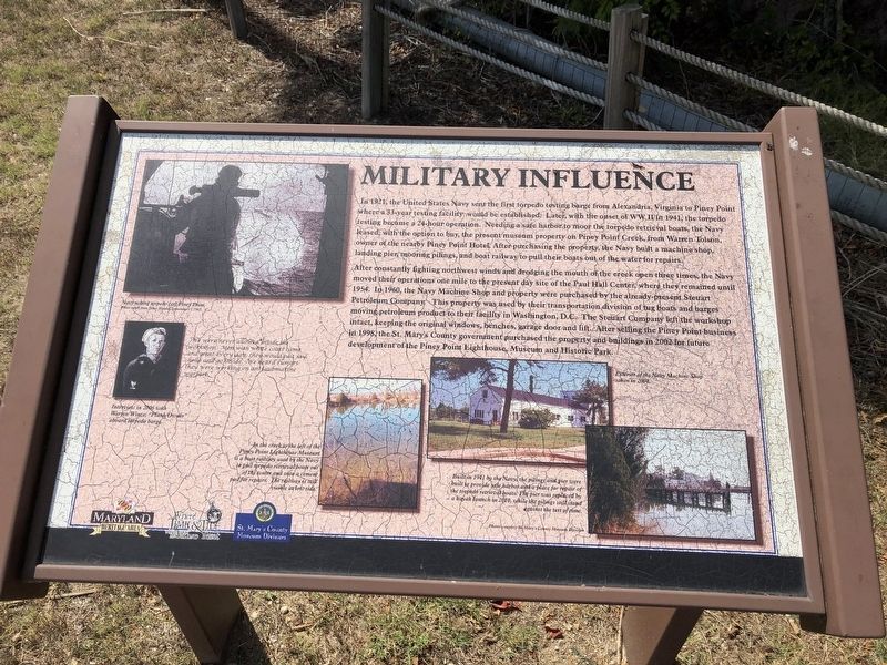
In 1921, the United States Navy sent the first torpedo testing barge from Alexandria, Virginia to Piney Point where a 33-year testing facility would be established. Later, with the onset of WW II in 1941, the torpedo testing became a 24-hour operation. Needing a safe harbor to moor the torpedo retrieval boats, the Navy leased, with the option to buy, the present museum property on Piney Point Creek, from Warren Tolson, owner of the nearby Piney Point Hotel. After purchasing the property, the Navy built a machine shop, landing pier, mooring pilings, and boat railway to pull their boats out of the water for repairs.
After constantly fighting northwest winds and dredging the mouth of the creek open three times, the Navy moved their operations one mile to the present day site of the Paul Hall Center, where they remained until 1954. In 1960, the Navy Machine Shop and property were purchased by the already present Steuart Petroleum Company. This property was used by their transportation division of tug boats and barges moving petroleum product to their facility in Washington, D.C. The Steuart Company left the workshop in 1998, the St. Mary's County government purchased the property and buildings in 2002 for future development of the Piney Point Lighthouse, Museum and Historic Park.
Erected by Maryland Heritage Area Authority, St. Mary's County Museum Division.
Topics. This historical marker is listed in these topic lists: Industry & Commerce • War, World II • Waterways & Vessels. A significant historical year for this entry is 1921.
Location. This marker has been replaced by another marker nearby. It was located near 38° 8.23′ N, 76° 31.722′ W. Marker was in Piney Point, Maryland, in St. Mary's County. Marker was on Lighthouse Road (Maryland Route 498) 0.1 miles west of Hotel Cove Lane, on the right when traveling west. Touch for map. Marker was at or near this postal address: 44740 Lighthouse Road, Piney Point MD 20674, United States of America. Touch for directions.
Other nearby markers. At least 8 other markers are within walking distance of this location. A different marker also named Military Influence (here, next to this marker); The Dory Boat (within shouting distance of this marker); Fueling Progress (within shouting distance of this marker); Piney Point Lighthouse (about 500 feet away, measured in a direct line); a different marker also named Piney Point Lighthouse (about 500 feet away); Potomac River Military Testing (about 500 feet away); Bay Lights (about 500 feet away); Osprey (about 500 feet away). Touch for a list and map of all markers in Piney Point.
Related marker. Click here for another marker that is related to this marker. This marker has been replaced by
Credits. This page was last revised on October 5, 2022. It was originally submitted on September 4, 2019, by Devry Becker Jones of Washington, District of Columbia. This page has been viewed 177 times since then and 8 times this year. Photos: 1, 2. submitted on September 4, 2019, by Devry Becker Jones of Washington, District of Columbia.

