Lonaconing in Allegany County, Maryland — The American Northeast (Mid-Atlantic)
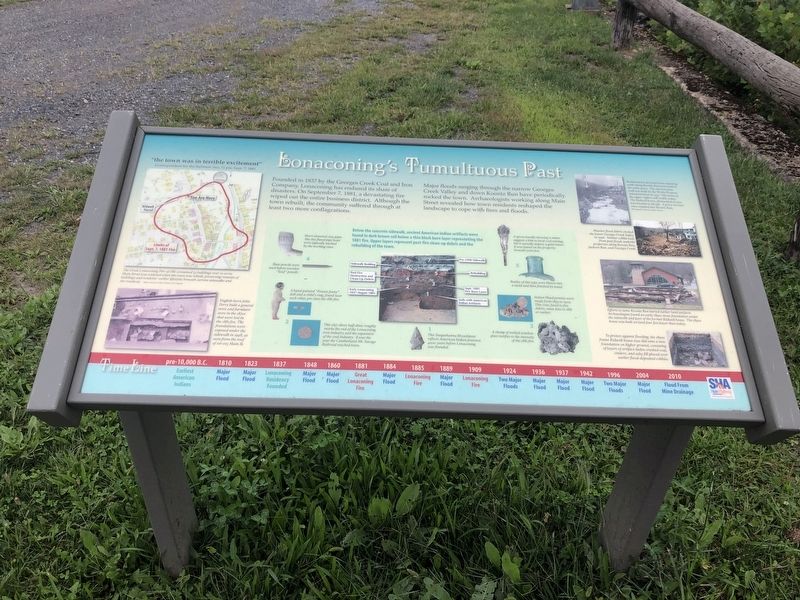
Lonaconing's Tumultuous Past
Founded in 1837 by the Georges Creek Coal and Iron Company, Lonaconing has endured its share of disasters. On September 7, 1881, a devastating fire wiped out the entire business district. Although the town rebuilt, the community suffered through at least two more conflagrations.
Major floods surging through the narrow Georges Creek Valley and down Koontz Run have periodically rocked the town. Archaeologists working along Main Street revealed how town residents reshaped the landscape to cope with fires and floods.
[Captions:]
"the town was in terrible excitement"
Correspondent for the Baltimore Sun, 11 pm, Sept. 7, 1881
The Great Lonaconing Fire of 1881 consumed 53 buildings over 10 acres. Main Street was widened when the town was rebuilt, preserving remains of buildings and residents' earlier lifestyles beneath current sidewalks and the roadway.
English-born John Perry built a general store and furniture store in the 1870s that were lost in the 1881 fire. The foundations were exposed under the sidewalk in 1998, as seen from the roof of 101-105 Main Street.
Below the concrete sidewalk, ancient American Indian artifacts were found in dark brown soil below a thin black layer representing the 1881 fire. Upper layers represent post-fire clean-up debris and the rebuilding of the town.
Short-stemmed clay pipes like this fluted pipe bowl were typically smoked by the working class.
Slate pencils were used before wooden "lead" pencils.
A hand-painted "Frozen Jenny" doll and a child's ring, found near each other, pre-date the 1881 fire.
This 1857 silver half-dime roughly marks the end of the Lonaconing iron industry and the expansion of the coal industry. It was the year Cumberland-Mt. Savage Railroad reached town.
This Susquehanna Broadspear reflects American Indian presence 4000 years before Lonaconing was founded.
A spoon handle showing a miner suggests a link to local coal mining, but it actually depicts a gold miner. It was found on the property, beneath your feet.
Bottles of this type were blown into a mold then finished by hand.
Indian Head pennies were made from 1859 to 1909. This coin, fused to fire debris, must date to 1881 or earlier.
A clump of melted window glass testifies to the intensity of the 1881 fire.
Rudimentary dry-laid stone-retaining walls along Koontz Run were built in the early 1900s. The current stone wall was built by the Works Progress Administration in 1937. The house in the upper right is still visible today. The Kidwell house, dismantled in 2011, was located
Massive flood debris choked the lower Georges Creek Valley in 1996. Similar cobble beds from past floods underlie properties along Koontz Run, Jackson Run, and Georges Creek.
Efforts to tame Koontz Run buried earlier land surfaces. Archaeologists found an early 1890s stone foundation under the sidewalk and part of the former Kidwell house. The 1890s house was built on land four feet lower than today.
To protect against flooding, the 1890s frame Kidwell house was slid onto a new foundation on higher ground, consisting of layers of artifact-laden crushed coal, cinders, and ashy fill placed over earlier flood-deposited cobbles.
Timeline
pre-10,000 B.C. Earliest American Indians
1810 Major Flood
1823 Major Flood
1837 Lonaconing Residency Founded
1848 Major Flood
1860 Major Flood
1881 Great Lonaconing Fire
1884 Major Flood
1885 Lonaconing Fire
1889 Major Flood
1909 Lonaconing Fire
1924 Two Major Floods
1936 Major Flood
1937 Major Flood
1942 Major Flood
1996 Two Major Floods
2004 Major Flood
2010 Flood From Mine Drainage
Erected by State Highway Administration.
Topics. This historical marker is listed in these topic lists: Disasters • Industry & Commerce • Native Americans • Settlements & Settlers. A significant historical date for this entry is September 7, 1881.
Location. 39° 34.041′ N, 78° 58.778′ W. Marker is in Lonaconing, Maryland, in Allegany County. Marker is on West Main Street (Maryland Route 36) just south of Pershing Street, on the right when traveling south. Touch for map. Marker is at or near this postal address: 55 West Main Street, Lonaconing MD 21539, United States of America. Touch for directions.
Other nearby markers. At least 8 other markers are within walking distance of this marker. In Honor and Remembrance (here, next to this marker); Lonaconing Veterans Memorial (within shouting distance of this marker); Our Heroes (within shouting distance of this marker); Vietnam Memorial (within shouting distance of this marker); Philadelphia Athletics (1925 - 1933) (about 500 feet away, measured in a direct line); Red Sox (1934 - 1941) (about 500 feet away); Coming Home to Lonaconing (about 500 feet away); Welcome to "Lefty" Grove Memorial Park (about 500 feet away). Touch for a list and map of all markers in Lonaconing.
Credits. This page was last revised on October 5, 2020. It was originally submitted on September 6, 2019, by Devry Becker Jones of Washington, District of Columbia. This page has been viewed 459 times since then and 70 times this year. Photos: 1, 2. submitted on September 6, 2019, by Devry Becker Jones of Washington, District of Columbia.

