Near Whitehead in Guysborough County, Nova Scotia — The Atlantic Provinces (North America)
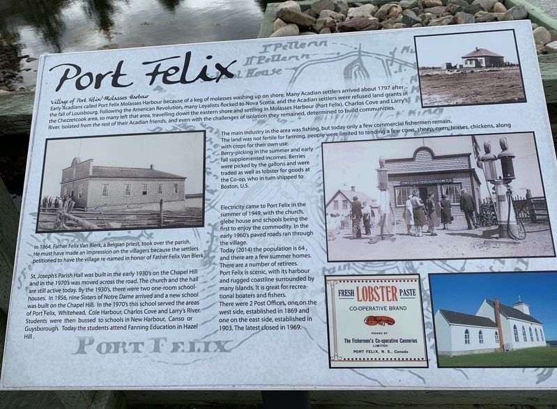
Port Felix
Village of Port Felix/Molasses Harbour
Early Acadians called Port Felix Molasses Harbour because of a keg of molasses washing up on shore. Many Acadian settlers arrived about 1797 after the fall of Louisbourg. Following the American Revolution, many Loyalists flocked to Nova Scotia, and the Acadian settlers were refused land grants in the Chezzetcook area, so many left that area, travelling down the eastern shore and settling in Molasses Harbour (Port Felix), Charlos Cove and Larry's River. Isolated from the rest of their Acadian friends, and even with the challenges of isolation they remained, determined to build communities.
The main industry in the area was fishing, but today only a few commercial fishermen remain. The land was not fertile for farming, people were limited to tending a few cows, sheep, oxen, horses, chickens, along with crops for their own use.
Berry-picking in the summer and early fall supplemented incomes. Berries were picked by the gallons and were traded as well as lobster for goods at the Co-op, who in turn shipped to Boston, U.S.
Electricity came to Port Felix in the summer of 1949, with the church, glebe house and schools being the first to enjoy the commodity. In the early 1960's paved roads ran through the village.
Today (2014) the population is 64, and there are a few summer homes. There are a number of retirees.
Port Felix is scenic, with its harbour and rugged coastline surrounded by many islands. It is great for recreational boaters and fishers.
There were 2 Post Offices, one on the west side, established in 1869 and one on the east side, established in 1903. The latest closed in 1969.
Left Photo: In 1864, Father Felix Van Blerk, a Belgian priest, took over the parish. He must have made an impression on the villagers because the settlers petitioned to have the village re-named in honor of Father Felix Van Blerk
St. Joseph's Parish Hall was built in the early 1930's on the Chapel Hill and in the 1970's was moved across the road. The church and the hall are still active today. By the 1930's, there were two one-room school- houses. In 1956, nine Sisters of Notre Dame arrived and a new school was built on the Chapel Hill. In the 1970's this school served the areas of Port Felix, Whitehead, Cole Harbour, Charlos Cove and Larry's River. Students were then bussed to schools in New Harbour, Canso or Guysborough. Today the students attend Fanning Education in Hazel Hill.
Topics and series. This historical marker is listed in this topic list: Settlements & Settlers. In addition, it is included in the Acadian History series list. A significant historical year for this entry is 1797.
Location. 45° 14.571′ N, 61° 11.487′ W. Marker is near Whitehead, Nova Scotia, in Guysborough County. Marker can be reached from Whitehead Road, on the right when traveling south. Marker is on a little wharf on the western end of the canal. Touch for map. Marker is in this post office area: Whitehead NS B0H 1T0, Canada. Touch for directions.
Other nearby markers. At least 8 other markers are within 8 kilometers of this marker, measured as the crow flies. Folklore & Trivia (here, next to this marker); Yankee Cove (about 150 meters away, measured in a direct line); The Canal (about 150 meters away); Whitehead (about 150 meters away); Welcome to Place Savalette (approx. 2.2 kilometers away); Captain Savalette (approx. 2.2 kilometers away); #5 Radar Unit R.C.A.F Station (approx. 7 kilometers away); We Will Remember/Nous Nous Souviendrons (approx. 7 kilometers away). Touch for a list and map of all markers in Whitehead.
Credits. This page was last revised on October 3, 2019. It was originally submitted on October 1, 2019, by Steve Stoessel of Niskayuna, New York. This page has been viewed 267 times since then and 23 times this year. Photo 1. submitted on October 1, 2019, by Steve Stoessel of Niskayuna, New York. • Andrew Ruppenstein was the editor who published this page.
Editor’s want-list for this marker. Photo of the marker within its surroundings • Can you help?
