Canso in Guysborough County, Nova Scotia — The Atlantic Provinces (North America)
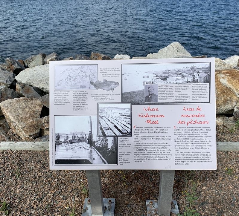
Where Fishermen Meet / Lieu de rencontre des pêcheurs
Inscription.
Fishermen sailed to this coast before the earliest explorers. In the early 1600s French and Basque fishermen dropped handlines in the waters.
By 1725 New Englanders were pulling in cod worth 150,000 pounds (New England currency) annually.
In the mid-nineteenth century, the Bank’s schooners used dories on the offshore grounds. This period was known as the “Age of Sail.”
In 1909 The Wren became the first successful steam-powered trawler in Canso. By the 1930’s engine-powered boats were gradually replacing the schooners in the inshore fishery and the demand for fresh fish ended the dominance of the salted cod.
En 1725, les colons de la Nouvelle-Angleterre pêchaient 150,000 livres (monnaie de la Nouvelle-Angleterre) de morue chaque année.
Vers la moitié du dix-neuvième siècle, les goélettes de bancs utilisaient des doris sur les lieux de pêches au large. C’était «L’Ère de la voile ».
En 1909, le Wren fut le premier chalutier à vapeur viable à Canso. Dans les années 30, les bateaux à moteur commencèrent à remplacer les goélettes pour la pêche côtière et la demande de poisson frais à la domination de la morue salée.
En haut à gauche: On voit sur la carte les bancs de pêche du large de la Nouvelle-Écosse. Les goélettes de Canso pêchaient principalement sur les bancs de Canso, Banquero et Misaine tandis que les goélettes plus grandes se rendaient jusqu’aux Grands Bancs de Terre-Neuve.
«La coste et fort poissonneuse, sur tout de molüe, maquereau et de haran…» Nicholas Denys, explorateur et négociant français du 17e siècle.
The business was carried on by his son, Abraham N. Whitman (shown in photograph) and later by his grandsons.
Les affaires ont été menées par son fils, Abraham N. Whitman (montré sur la photo) et plus tard par ses petits-fils.
Topics and series. This historical marker is listed in these topic lists: Industry & Commerce • Waterways & Vessels. In addition, it is included in the Acadian History series list. A significant historical year for this entry is 1725.
Location. 45° 20.267′ N, 60° 59.616′ W. Marker is in Canso, Nova Scotia, in Guysborough County. Marker can be reached from Water Street. Touch for map. Marker is in this post office area: Canso NS B0H 1H0, Canada. Touch for directions.
Other nearby markers. At least 8 other markers are within 19 kilometers of this marker, measured as the crow flies. Harbour Traffic/Le traffic du port (about 90 meters away, measured in a direct line); The Canso Islands/ Les îles Canso (about 90 meters away); Welcome to Canso Harbour/Bienvenue au Port de Canso (about 90 meters away); We Heard the News First/Nous étions les premiers à avoir les nouvelles (about 210 meters away); In Memory of Tusker 914 En mémoire de (approx. 0.3 kilometers away); Canso (approx. 0.3 kilometers away); Canso Soldiers Memorial (approx. 0.9 kilometers away); Folklore & Trivia (approx. 18.8 kilometers away). Touch for a list and map of all markers in Canso.
Credits. This page was last revised on February 24, 2022. It was originally submitted on October 4, 2019, by Steve Stoessel of Niskayuna, New York. This page has been viewed 139 times since then and 10 times this year. Photo 1. submitted on October 4, 2019, by Steve Stoessel of Niskayuna, New York. • Andrew Ruppenstein was the editor who published this page.
