Sappington in St. Louis County, Missouri — The American Midwest (Upper Plains)
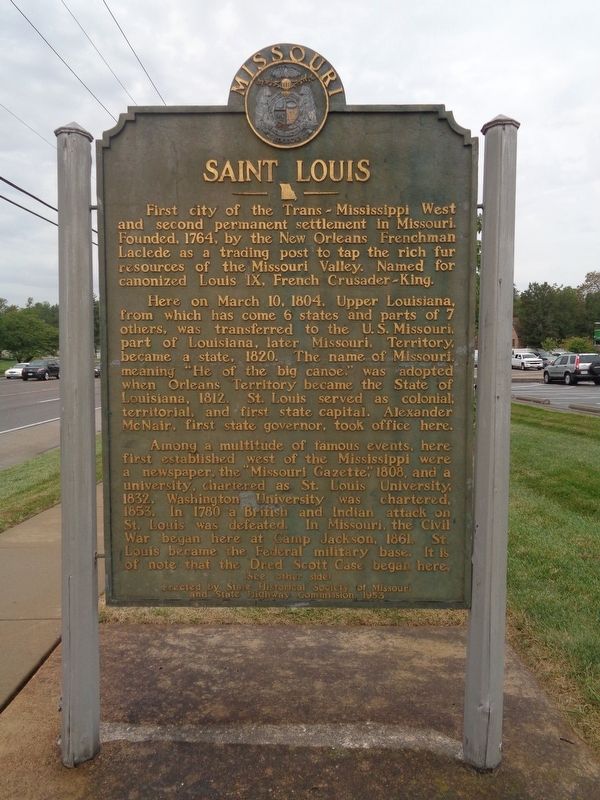
Saint Louis
Here on March 10, 1804, Upper Louisiana, from which has come 6 states and parts of 7 others, was transferred to the U.S. Missouri, part of Louisiana later Missouri, Territory, became a state, 1820. The name Missouri, meaning "He of the big canoe," was adopted when Orleans Territory became the State of Louisiana, 1812. St. Louis served as colonial, territorial, and first state capital. Alexander McNair, first state governor, took office here.
Among a multitude of famous events, here first established west of Mississippi were a newspaper, the "Missouri Gazette," 1808, and a university, chartered as St. Louis University, 1832. Washington University was chartered, 1853. In 1780 a British and Indian attack on St. Louis was defeated. In Missouri, the Civil War began here at Camp Jackson, 1861. St. Louis became the Federal military base. It is of note that the Dred Scott Case began here.
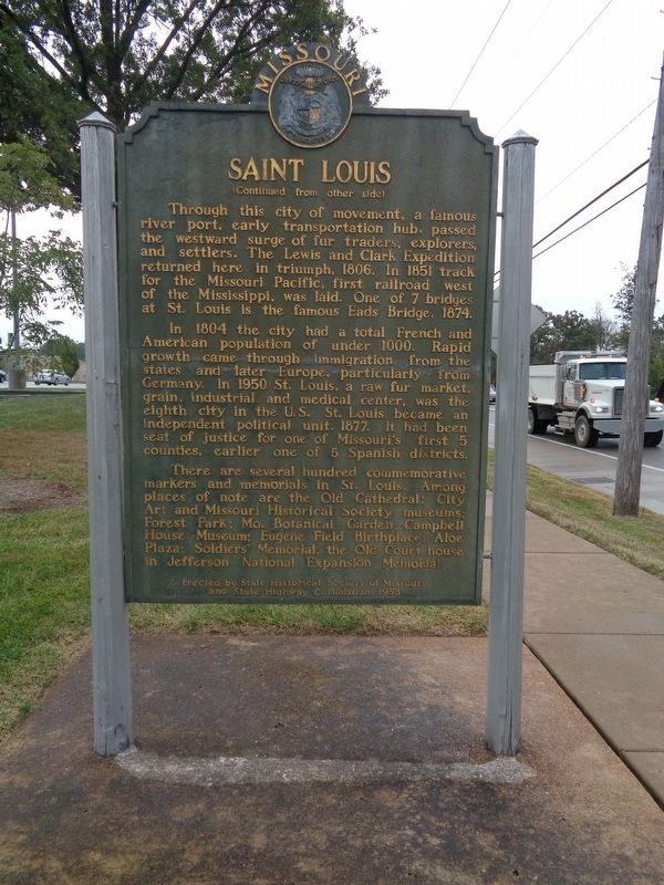
Through this city of movement, a famous river port, early transportation hub, passed the westward surge of fur traders, explorers, and settlers. The Lewis and Clark Expedition returned here in triumph, 1806. In 1851 track for the Missouri Pacific, first railroad west of the Mississippi, was laid. One of 7 bridges at St. Louis is the famous Eads Bridge, 1874.
In 1804 the city had a total French and American population of under 1000. Rapid growth through immigration from the states and later Europe, particularly from Germany. In 1950 St Louis, a raw fur market, grain, industrial, and medical center, was the eighth city in the U.S. St. Louis became an independent political unit, 1877. It had been seat of justice for one of Missouri's first 5 counties, earlier one of 5 Spanish districts.
There are several hundred commemorative markers and memorials in St. Louis. Among places of note are the Old Cathedral; City Art and Missouri Historical Society museums; Forest park; Mo. Botanical Garden; Campbell House Museum; Eugene Field Birthplace; Aloe Plaza; Soldiers' Memorial; the Old Court House in Jefferson National Expansion Memorial.
Erected 1953 by State Historical Society of Missouri and State Highway Commission.
Topics and series. This historical marker is listed in these topic lists: Education • Industry & Commerce • Settlements & Settlers • Waterways & Vessels. In addition, it is included in the Missouri, The State Historical Society of series list.
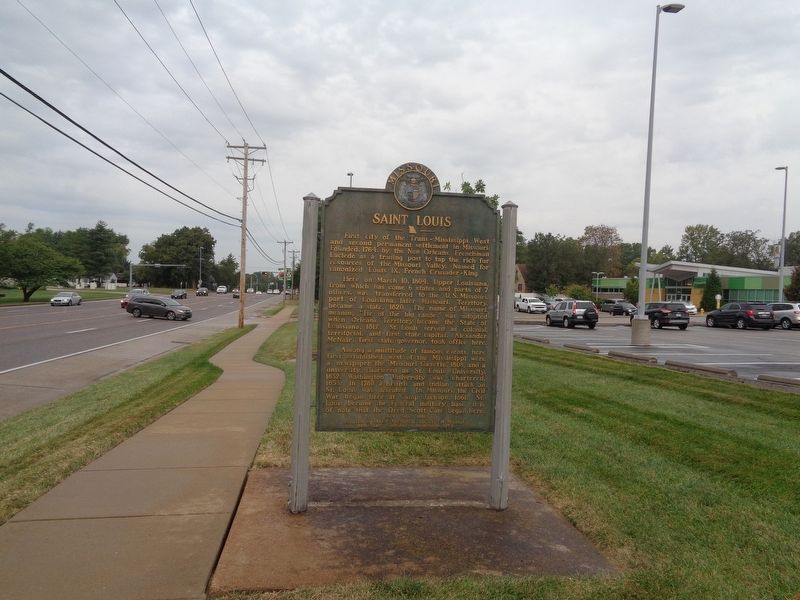
Location. 38° 31.718′ N, 90° 22.598′ W. Marker is in Sappington, Missouri, in St. Louis County. Marker is on Lindbergh Boulevard (U.S. 61/67) 0.2 miles west of Roxanna Drive, on the right when traveling north. Marker is located in front of Lindbergh High School, which is in the unincorporated community of Sappington, Missouri. Touch for map. Marker is at or near this postal address: 5000 Lindbergh Boulevard, Saint Louis MO 63126, United States of America. Touch for directions.
Other nearby markers. At least 8 other markers are within 2 miles of this marker, measured as the crow flies. All Gave Some, Some Gave All (approx. 1.9 miles away); In Memory of August A. Busch, Jr. (approx. 2 miles away); Ulysses S. Grant and the Farm at White Haven (approx. 2 miles away); Gravois Creek Greenway - Clydesdale Park (approx. 2 miles away); White Haven (approx. 2.1 miles away); Grant's Departure / ~150 Years Ago (approx. 2.1 miles away); Changes at White Haven / ~150 Years Ago - Grants Horses (approx. 2.1 miles away); A Slave Plantation (approx. 2.1 miles away).
Regarding Saint Louis. While the marker presents a short, unique history of the city of Saint Louis up to 1953, there are three notable factual errors: (1) Missouri became a state, officially on August 10, 1821, not 1820; (2) St. Louis was not Missouri's first state capital, though legislators of the First General Assembly met there in 1820.
They designated St. Charles to be the state's temporary capital, and lawmakers met there from 1821 to 1826; (3) St. Louis became an independent city/political unit on August 22, 1876, not in the year 1877.
The marker should also be noted for its datedness, as a lot has happened since 1953. At the time, St. Louis was the eighth largest city in the United States; in 2018, it was the 61st largest city. The marker states that there were 7 bridges at St. Louis, but at least three have been added and at least three of those seven bridges are not for vehicular use. 1953 was one of those "last years" before the Interstate Highway System, and it was also the last year that St. Louis had two Major League Baseball teams (the Cardinals and the Browns, the latter moving to Baltimore in 1954). All of the "places of note" listed on the marker are still open to the public as of 2019. The Jefferson National Expansion Memorial park would become the Gateway Arch National Park, as it was re-designated as a national park in 2018. The most notable addition to the city of St. Louis since 1953 was the Gateway Arch (built, starting in 1963, and opened in 1967).
Throughout the 1950s, the Missouri State Historical Society and State Highway Commission placed several historical markers all over Missouri. At least one was placed in every county. However, there was not one placed within St. Louis city limits. The "Saint Louis" marker was placed on the grounds in front of Lindbergh High School, which has a St. Louis address. Technically, the school is in the unincorporated area of Sappington, which is in St. Louis County. It is said that the marker was placed on a major US route at the time to gather maximum exposure.
Also see . . . St. Louis on Wikipedia. The Wikipedia page for the city of St. Louis, Missouri, which contains history, statistics and more (Submitted on October 10, 2019, by Jason Voigt of Glen Carbon, Illinois.)
Credits. This page was last revised on October 11, 2019. It was originally submitted on October 10, 2019, by Jason Voigt of Glen Carbon, Illinois. This page has been viewed 309 times since then and 39 times this year. Photos: 1, 2, 3. submitted on October 10, 2019, by Jason Voigt of Glen Carbon, Illinois. • Devry Becker Jones was the editor who published this page.


