Larrys River in Guysborough County, Nova Scotia — The Atlantic Provinces (North America)
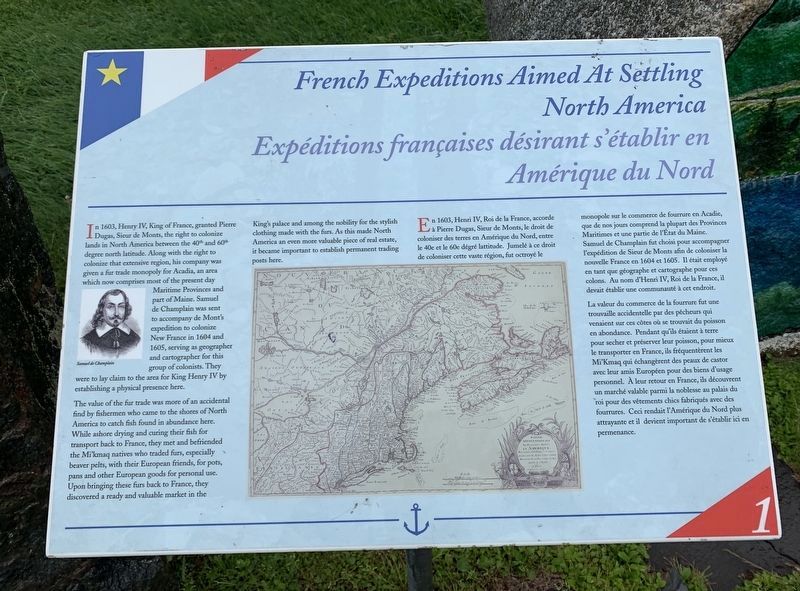
French Expeditions Aimed At Settling North America
Expéditions françaises destinées à s'établir en Amérique du Nord
Inscription.
The value of the fur trade was more of an accidental find by find by fishermen who came to the shores of North America to catch fish found in abundance here. While ashore drying and curing their fish for transport back to France, they met and befriended the Mi'kmaq natives who traded furs, especially beaver pelts, with their European friends, for pots, and other European goods for personal use. Upon bringing these furs back to France, they discovered a ready and valuable market in the King's palace and among the nobility for the stylish clothing made with the furs. As this made North America an even more valuable piece of real estate, it became important to establish permanent trading posts here.
La valeur du commerce de la fourrure fut une trouvaille accidentelle par des pêcheurs qui venaient sur ces côtes où se trouvait du poisson en abondance. Pendant qu'ils étaient à terre pour secher et préserver leur poisson, pour mieux le transporter en France, ils fréquentèrent les Mi'Kmaq qui échangèrent des peaux de castor avec leur amis Européen pour des biens d'usage personnel. A leur retour en France, ils découvrent un marché valable parmi la noblesse au palais du roi pour vêtements chics fabriqués
avec des fourrures. Ceci rendait l'Amérique du Nord plus attrayante et il devient important de s'établir ici en permenance. (Marker Number 1.)
Topics and series. This historical marker is listed in these topic lists: Exploration • Settlements & Settlers. In addition, it is included in the Acadian History series list. A significant historical year for this entry is 1603.
Location. 45° 13.299′ N, 61° 22.641′ W. Marker is in Larrys River, Nova Scotia, in Guysborough County. Marker is at the intersection of Marine Drive (Nova Scotia Route 316) and Ballfield Loop, on the right when traveling west on Marine Drive. Touch for map. Marker is in this post office area: Larrys River NS B0H 1T0, Canada. Touch for directions.
Other nearby markers. At least 8 other markers are within walking distance of this marker. Settlement of l’Acadie 1604/1605 (here, next to this marker); Samuel de Champlain Meets Captain Savalette On Shores of Tor Bay (here, next to this marker); Acadian Dyke Building Along the Bay of Fundy (here, next to this marker); Grand-Pré (a few steps from this marker); The Great Upheaval 1755-1763 (a few steps from this marker); The Scattering of a People (a few steps from this marker); The Resettlement (a few steps from this marker); Founding Families of the Acadian Communities Along Tor Bay 1797-1900 (a few steps from this marker). Touch for a list and map of all markers in Larrys River.
Also see . . . French Colonization of America. (Submitted on October 17, 2019, by Steve Stoessel of Niskayuna, New York.)
Credits. This page was last revised on October 18, 2019. It was originally submitted on October 17, 2019, by Steve Stoessel of Niskayuna, New York. This page has been viewed 179 times since then and 13 times this year. Photos: 1, 2, 3. submitted on October 17, 2019, by Steve Stoessel of Niskayuna, New York. • Andrew Ruppenstein was the editor who published this page.


