Buckhead in Atlanta in Fulton County, Georgia — The American South (South Atlantic)
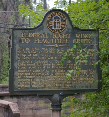
Federal Right Wing to Peachtree Creek
Hooker´s 20th A.C. left camp on Mt. Paran Rd., crossed Nancy´s Cr., & moved E. on Pace´s Ferry Rd. to occupy the gap between the 14th A.C. & Howard´s 4th A.C. which had reached Buckhead at noon via Power´s Ferry Rd. from where it had crossed the Chattahoochee River.
Erected 1956. (Marker Number 060-26A.)
Topics and series. This historical marker is listed in this topic list: War, US Civil. In addition, it is included in the Georgia Historical Society series list. A significant historical date for this entry is July 18, 1878.
Location. 33° 50.96′ N, 84° 25.983′ W. Marker is in Atlanta, Georgia, in Fulton County. It is in Buckhead. Marker is at the intersection of Paces Ferry Road NW and Paces Place NW, on the right when traveling west on Paces Ferry Road NW. THe Marker is on the bank of Peachtree Creek where it passes under Paces Ferry Road. Touch for map. Marker is in this post office area: Atlanta GA 30319, United States of America. Touch for directions.
Other nearby markers. At least 8 other markers are within 2 miles of this marker, measured as the crow flies. Paces Ferry United Methodist Church (approx. 0.4 miles away); Federal Right Wing (approx. 0.4 miles away); Union Defense Line (approx. 1.2 miles away); Palmer’s & Hooker’s A.C. Cross the Chattahoochee (approx. 1.2 miles away); Old Pace’s Ferry Road (approx. 1.3 miles away); The Errant Pontoon Bridge: Paces Ferry (approx. 1½ miles away); The 14th & 20th A.C. Cross at Pace's Ferry (approx. 1½ miles away); a different marker also named The 14th & 20th A.C. Cross at Pace’s Ferry (approx. 1½ miles away). Touch for a list and map of all markers in Atlanta.
Credits. This page was last revised on February 8, 2023. It was originally submitted on December 10, 2008, by David Seibert of Sandy Springs, Georgia. This page has been viewed 1,489 times since then and 22 times this year. Photo 1. submitted on December 10, 2008, by David Seibert of Sandy Springs, Georgia. • Craig Swain was the editor who published this page.
Editor’s want-list for this marker. A wide shot of the marker and its surroundings. • Can you help?
