Near Saint Croix Falls in Polk County, Wisconsin — The American Midwest (Great Lakes)
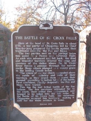
The Battle of St. Croix Falls
The two parties met on the portage below this point in a fierce and valorous fight. As each side advanced and fell back, the dead and wounded warriors littered the crags and crevices of the dalles where the St. Croix River forces a passage through the narrow rocks. Many others plunged to a watery grave in the boiling floods below.
"The voices of the war chiefs resounded above the rattle of musketry and yells of their warriors, as they urged them to stand their ground," according to Indian tales of the battle. First confident, finally desperate, the Fox and Sioux were routed.
This was the last tribal battle of the Fox Indians. The few survivors retreated far to the south, their tribal fire extinguished, and begged to be taken into the Sac tribe. In the Battle of St. Croix Falls, the victorious Chippewas secured this territory, making it safe for the white settlers to come.
Erected 1964 by the Wisconsin Historical Society. (Marker Number 132.)
Topics and series. This historical marker is listed in this topic list: Wars, US Indian. In addition, it is included in the Wisconsin Historical Society series list. A significant historical year for this entry is 1770.
Location. 45° 25.658′ N, 92° 38.741′ W. Marker is near Saint Croix Falls, Wisconsin, in Polk County. Marker is on State Highway 87, 0.2 miles north of Wisconsin Street, on the left when traveling north. Marker is north of the city in Lions Park. Touch for map. Marker is in this post office area: Saint Croix Falls WI 54024, United States of America. Touch for directions.
Other nearby markers. At least 8 other markers are within 2 miles of this marker, measured as the crow flies. St. Croix Falls Lions Park (a few steps from this marker); Saint Croix Falls Hydroelectric Project (approx. 0.8 miles away in Minnesota); Where are the Falls? (approx. 0.8 miles away); Gaylord Nelson (approx. 0.8 miles away); River Spirit (approx. one mile away); Thompson–Boughton Mill (approx. one mile away); Where Are The Falls of the St. Croix? (approx. 1.1 miles away); Chisago Hotel (approx. 1.8 miles away in Minnesota). Touch for a list and map of all markers in Saint Croix Falls.
Credits. This page was last revised on February 22, 2021. It was originally submitted on December 14, 2008, by Keith L of Wisconsin Rapids, Wisconsin. This page has been viewed 2,155 times since then and 88 times this year. Photos: 1, 2, 3. submitted on December 14, 2008, by Keith L of Wisconsin Rapids, Wisconsin. • Craig Swain was the editor who published this page.


