Petersburg, Virginia — The American South (Mid-Atlantic)
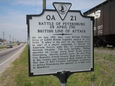
Battle of Petersburg, 25 April 1781
British Line of Attack
Inscription.
On 24 Apr. 1781, Maj. Gen. William Phillips’s force of 2,500 British regulars landed at City Point, 12 miles to the east on the James River, as part of a major campaign to disrupt the American force’s main line of communication through Virginia. The next morning, Phillips marched his troops along River Road toward Petersburg. Shortly before noon, he and Brig. Gen. Benedict Arnold formed their line of battle in this vicinity and launched their attack on the first line of 500 Virginia militiamen positioned to defend Petersburg one-quarter of a mile west in Blandford.
Erected 2005 by Department of Historic Resources. (Marker Number QA-21.)
Topics and series. This historical marker is listed in this topic list: War, US Revolutionary. In addition, it is included in the Virginia Department of Historic Resources (DHR) series list. A significant historical date for this entry is April 24, 1781.
Location. 37° 14.341′ N, 77° 22.44′ W. Marker is in Petersburg, Virginia. Marker is on Washington Street (Virginia Route 36), on the right when traveling west. Marker is located next to the railroad tracks on Washington Street, just west of Courthouse Road. Touch for map. Marker is in this post office area: Petersburg VA 23803, United States of America. Touch for directions.
Other nearby markers. At least 8 other markers are within walking distance of this marker. Newmarket Racecourse (about 400 feet away, measured in a direct line); First Maine Heavy Artillery Monument (approx. 0.4 miles away); Lee's Last Offensive (approx. half a mile away); Prince George Court House Road (approx. half a mile away); Colquitt's Salient (approx. half a mile away); Wasted Valor (approx. half a mile away); a different marker also named Colquitt’s Salient (approx. half a mile away); Siege of Petersburg—Lee Strikes Back (approx. 0.6 miles away). Touch for a list and map of all markers in Petersburg.
Related markers. Click here for a list of markers that are related to this marker.
Also see . . . Battle of Blanford, also called the Battle of Petersburg. “Around 2:00 pm Phillips halted his column, then about one mile (1.6 km) from the American lines, and organized his forces for battle. On his right, Colonel Robert Abercrombie was to lead a battalion of light infantry and the company of 50 jägers along the river to drive the American left back to the Pocahontas Bridge. Lieutenant Colonel Thomas Dundas was to lead the 78th and 80th Foot to attempt a flanking maneuver against the
American right, and Phillips held the second light infantry battalion and the Loyalist units of Simcoe and Arnold in reserve.” (Submitted on April 23, 2016.)
Credits. This page was last revised on February 2, 2023. It was originally submitted on December 20, 2008, by Bill Coughlin of Woodland Park, New Jersey. This page has been viewed 1,284 times since then and 76 times this year. Photos: 1, 2, 3. submitted on December 20, 2008, by Bill Coughlin of Woodland Park, New Jersey.


