Maskell in Dixon County, Nebraska — The American Midwest (Upper Plains)
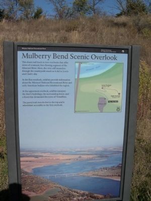
Mulberry Bend Scenic Overlook
At the first overlook, exhibits provide information about the Missouri National Recreational River and early American Indians who inhabited the region.
At the uppermost overlook, exhibits interpret the river's hydrology, the surrounding forest, and a flood that devastated the town of Vermillion.
The paved trail rises 60 feet to the top and is wheelchair accessible to the first overlook.
Erected by National Park Service - Missouri National Recreational River.
Topics. This historical marker is listed in this topic list: Waterways & Vessels.
Location. 42° 42.9′ N, 96° 57.118′ W. Marker is in Maskell, Nebraska, in Dixon County. Marker is on State Highway 15. Marker is on the trail from the parking lot near the bridge crossing into South Dakota. Touch for map. Marker is in this post office area: Maskell NE 68751, United States of America. Touch for directions.
Other nearby markers. At least 8 other markers are within 5 miles of this marker, measured as the crow flies. The Great Missouri River (here, next to this marker); Confluence of the Vermillion and Missouri Rivers (approx. 4.2 miles away in South Dakota); Vermillion (approx. 4.2 miles away in South Dakota); Lewis and Clark / Vermillion (approx. 4.2 miles away in South Dakota); Welcome to Cotton Park (approx. 4.2 miles away in South Dakota); Old Vermillion (approx. 4.3 miles away in South Dakota); Grand Lodge Constitution Site (approx. 4.3 miles away in South Dakota); Site of the First Permanent School House in Dakota Territory (approx. 4.3 miles away in South Dakota).
Credits. This page was last revised on June 16, 2016. It was originally submitted on January 7, 2009, by Rich Pfingsten of Forest Hill, Maryland. This page has been viewed 2,044 times since then and 23 times this year. Photos: 1, 2. submitted on January 7, 2009, by Rich Pfingsten of Forest Hill, Maryland. • Bill Pfingsten was the editor who published this page.

